


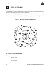
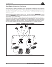

A GPS Overview
MiLLennium Command Descriptions Manual 51
All these parts operate together to provide accurate three dimensional positioning, timing and velocity data to users
worldwide.
The Space Segment
The space segment is composed of the NAVSTAR GPS satellites. The final constellation of the system consists of 24
satellites in six 55° orbital planes, with four satellites in each plane. The orbit period of each satellite is
approximately 12 hours at an altitude of 10,898 nautical miles. This provides a
GPS receiver with six to twelve
satellites in view from any point on earth, at any particular time.
The
GPS satellite signal identifies the satellite and provides the positioning, timing, ranging data, satellite status and
the corrected ephemerides (orbit parameters) of the satellite to the users. The satellites can be identified either by
the Space Vehicle Number (
SVN) or the Pseudorandom Code Number (PRN). The PRN is used by the NovAtel
GPSCard.
The
GPS satellites transmit on two L-band frequencies; one centred at 1575.42 MHz (L1) and the other at 1227.60
MHz (L2). The L1 carrier is modulated by the C/A code (Coarse/Acquisition) and the P code (Precision) which
is encrypted for military and other authorized users. The L2 carrier is modulated only with the P code.
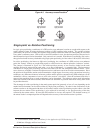
The Control Segment
The control segment consists of a master control station, five reference stations and three data up-loading stations
in locations all around the globe.
The reference stations track and monitor the satellites via their broadcast signals. The broadcast signals contain
the ephemeris data of the satellites, the ranging signals, the clock data and the almanac data. These signals are
passed to the master control station where the ephemerides are re-computed. The resulting ephemerides
corrections and timing corrections are transmitted back to the satellites via the data up-loading stations.
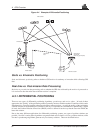
The User Segment
The user segment, such as the NovAtel GPSCard receiver, consists of equipment which tracks and receives the
satellite signals. The user equipment must be capable of simultaneously processing the signals from a minimum
of four satellites to obtain accurate position, velocity and timing measurements. A user can also use the data
provided by the satellite signals to accomplish specific application requirements.
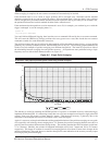
A.2 HEIGHT RELATIONSHIPS
What is a geoid?
The equipotential surface which best represents mean sea-level where an equipotential surface is any surface where
gravity is constant. This surface not only covers the water but is projected throughout the continents. Most surfaces
in North America use this surface as its zero value, i.e. all heights are referenced to this surface.
What is an ellipsoid?
An ellipsoid, also known as a spheroid, is a mathematical surface which is sometimes used to represent the earth.
Whenever you see latitudes and longitudes describing the location, this coordinate is being referenced to a specific
ellipsoid. GPS positions are referred to an ellipsoid known as WGS84 (World Geodetic System of 1984).
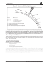
What is the relationship between a geoid and an ellipsoid?
The relationship between a geoid and an ellipsoid is shown in Figure A-2.