


D Logs summary
188 MiLLennium Command Descriptions Manual
RTKA/B Computed Position - Time Matched
RTK
This log represents positions that have been computed from time matched reference and remote observations.
There is no reference station extrapolation error on these positions but because they are based on buffered
measurements, they lag real time by some amount depending on the latency of the data link. If the remote receiver
has not been enabled to accept RTK differential data, or is not actually receiving data leading to a valid solution,
this will be reflected by the code shown in field #16 (RTK ststus) and #17 (position type).
The data in the logs will change only when a reference observation (RTCM Type 59 or the corresponding RTCA
Type 7) changes. If the log is being output at a fixed rate and the differential data is interrupted, then the
RTKA/B
logs will continue to be output at the same rate but the position and time will not change.
A good message trigger for this log is "
ONCHANGED". Then, only positions related to unique reference station
messages will be produced, and the existence of this log will indicate a successful link to the reference station.
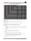
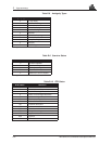
RTKA
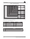
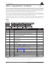
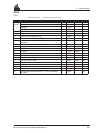
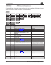
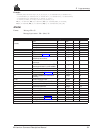
Structure:
Example:
$RTKA,872,174962.00,8,7,7,51.11358039754,-114.04358003164,1059.4105,
-16.2617,61,0.0036,0.0039,0.0066,0,0,4,0,119*33[CR][LF]
$RTKA week seconds #sv #high L1L2 #high
lat
lon
hgt undulation datum ID
lat σ lon σ hgt σ soln status rtk status
posn type dyn mode stn ID *xx [CR][LF]
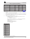
Field # Field type Data Description Example
1 $RTKA Log header $RTKA
2 week GPS week number 872
3 seconds GPS time into the week (in seconds) 174962.00
4 #sv Number of matched satellites; may differ from the number in view. 8
5 #high Number of matched satellites above RTK mask angle; observations from satellites
below mask are heavily de-weighted
7
6 L1L2 #high Number of matched satellites above RTK mask angle with both L1 and L2 available 7
7 lat Latitude of position in current datum, in decimal fraction format. A negative sign
implies South latitude
51.11358039754
8 lon Longitude of position in current datum, in decimal fraction format. A negative sign
implies West longitude
-114.04358003164
9 hgt Height of position in current datum, in metres above mean sea level 1059.4105
10 undulation Geoidal separation, in metres, where positive is above ellipsoid and negative is
below ellipsoid
-16.2617
11 datum ID Current datum (see Appendix G)61
12
lat
σ
Standard deviation of latitude solution element, in metres 0.0036
13
lon
σ
Standard deviation of longitude solution element, in metres 0.0039
14
hgt
σ
Standard deviation of height solution element, in metres 0.0066
15 soln status Solution status (seeTable D-1)0
16 rtk status RTK status (see Tables D-3, D-4 ) 0
17 posn type Position type (see Table D-2)4
18 dyn mode Dynamics mode (0= static, 1= kinematic) 0
19 stn ID Reference station identification (RTCM: 0 - 1023, or RTCA: 266305 - 15179385) 119
20 *xx Checksum *33
21 [CR][LF] Sentence terminator [CR][LF]