


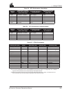


K GPS Glossary of Terms
MiLLennium Command Descriptions Manual 247
VDOP — Vertical Dilution of Precision. This is related to GDOP. It describes the effects of geometry on
vertical positioning accuracy. It is defined to be the square root of the diagonal of a normalized
(assume measurement noise = 1) covariance matrix which corresponds to vertical position error.
Variable field — by NMEA standards, a data field which may or may not contain a decimal point and which
may vary in precision following the decimal point depending on the requirements and the accuracy
of the measuring device.
WGS84 — World Geodetic System 1984 is an ellipsoid designed to fit the shape of the entire Earth as well as
possible with a single ellipsoid. It is often used as a reference on a worldwide basis, while other
ellipsoids are used locally to provide a better fit to the Earth in a local region. GPS uses the centre
of the WGS84 ellipsoid as the centre of the GPS ECEF reference frame.
Waypoint — a reference point on a track.
Wide Lane — a particular integer ambiguity value on one carrier phase range measurement or double
difference carrier phase observation when the difference of the L1 and L2 measurements is used. It
is a carrier phase observable formed by subtracting L2 from L1 carrier phase data: Φ' = Φ
1
- Φ
2
. The
corresponding wavelength is 86.2 cm