


A GPS Overview
52 MiLLennium Command Descriptions Manual
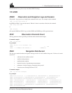
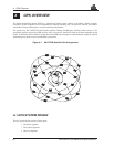
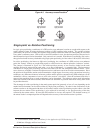
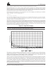
Figure A-2 Illustration of GPSCard Height Measurements
From the above diagram, and the formula h = H + N, to convert heights between the ellipsoid and geoid we require
the geoid-ellipsoid separation value. This value is not easy to determine. A world-wide model is generally used to
provide these values. NovAtel GPS receivers store this value internally. This model can also be augmented with
local height and gravity information. A more precise geoid model is available from government survey agencies
eg. U.S. National Geodetic Survey or Geodetic Survey of Canada (refer to Appendix F, Standards and References).
Why is this important for GPS users?
The above formula is critical for GPS users as they typically obtain ellipsoid heights and need to convert these into
mean sea-level heights. Once this conversion is complete, users can relate their GPS derived heights to more
“usable” mean sea-level heights.
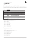
A.3 GPS POSITIONING
GPS positioning can be categorized as follows:
1. single-point or relative
2. static or kinematic
3. real-time or post-mission data processing
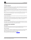
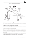
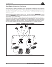
A distinction should be made between accuracy and precision. Accuracy refers to how close an estimate or
measurement is to the true but unknown value; precision refers to how close an estimate is to the mean (average)
estimate. Figure A-3 illustrates various relationships between these two parameters: the true value is "located" at
the intersection of the cross-hairs, the centre of the shaded area is the "location" of the mean estimate, and the radius
of the shaded area is a measure of the uncertainty contained in the estimate.
Notes: References:
h = H + N 1 Topography
N = h - H 2 Geoid (mean sea level)
H = GPSCard computed height above/below geoid
N = Geoidal Height (undulation)
3 Spheroid (ellipsoid)
h = GPS system computed height above the spheroid