


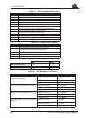
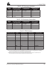

K GPS Glossary of Terms
242 MiLLennium Command Descriptions Manual
Doppler aiding — a signal processing strategy, which uses a measured Doppler shift to help a receiver
smoothly track the GPS signal, to allow more precise velocity and position measurement.
Double-Difference — a position estimation mechanization which uses observations which are differenced
between receiver channels and between the reference and remote receivers.
Double-Difference Carrier Phase Ambiguity (or sometimes double difference ambiguity or ambiguity, for
short) — carrier phase ambiguities which are differenced between receiver channels and between the
reference and remote receivers. They are estimated when a double difference mechanism is used for
carrier phase positioning.
Earth-Centred-Earth-Fixed (ECEF) — a right-hand Cartesian coordinate system with its origin located at
the centre of the Earth. The coordinate system used by GPS to describe three-dimensional location.
ECEF — Earth-Centred-Earth-Fixed. This is a coordinate-ordinate system which has the X-coordinate in the
earth's equatorial plane pointing to the Greenwich prime meridian, the Z-axis pointing to the north
pole, and the Y-axis in the equatorial plane 90° from the X-axis with an orientation which forms a
right-handed XYZ system.
Ellipsoid — a smooth mathematical surface which represents the earth’s shape and very closely approximates
the geoid. It is used as a reference surface for geodetic surveys, see the
PRTKA/B log in Appendix D.
Ellipsoidal Height — height above a defined ellipsoid approximating the surface of the earth.
Ephemeris — a set of satellite orbit parameters that is used by a GPS receiver to calculate precise GPS satellite
positions and velocities. The ephemeris is used in the determination of the navigation solution and
is updated periodically by the satellite to maintain the accuracy of GPS receivers.
Ephemeris Data — the data downlinked by a GPS satellite describing its own orbital position with time.
Epoch — same as measurement time epoch. The local time at which a GPSCard takes a measurement.
Field — a character or string of characters immediately preceded by a field delimiter.
Fixed Ambiguity Estimates — carrier phase ambiguity estimates which are set to a given number and held
constant. Usually they are set to integers or values derived from linear combinations of integers.
Fixed Discrete Ambiguity Estimates — carrier phase ambiguities which are set to values which are members
of a predetermined set of discrete possibilities, and then held constant.
Fixed field — a field in which the number of characters is fixed. For data fields, such fields are shown in the
sentence definitions with no decimal point. Other fields which fall into this category are the address
field and the checksum field (if present).
Fixed Integer Ambiguity Estimates — carrier phase ambiguities which are set to integer values and then held
constant.
Flash ROM — Programmable read-only memory.
Floating Ambiguity Estimates — ambiguity estimates which are not held to a constant value, but are allowed
to gradually converge to the correct solution.
GDOP — Geometric Dilution of Precision - A numerical value expressing the confidence factor of the position
solution based on current satellite geometry. Assumes that 3D position (latitude, longitude, height)
and receiver clock offset (time) are variables in the solution. The lower the GDOP value, the greater
the confidence in the solution.
Geoid — the shape of the earth if it were considered as a sea level surface extended continuously through the
continents. The geoid is an equipotential surface coincident with mean sea level to which at every
point the plumb line (direction in which gravity acts) is perpendicular. The geoid, affected by local
gravity disturbances, has an irregular shape. See the
PRTKA/B log in Appendix D.
Geodetic datum — the reference ellipsoid surface that defines the coordinate system.