


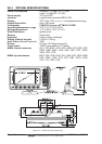


CPF180i and CPF300i Page 137
21. APPENDIX: TERMS
ALT (Altitude) – Shows the Altitude of the GPS Antenna on the mean sea level. It i received
from GPS, sentence GGA.
APP Wind DIR SPD (Apparent Wind Direction) – Shows the Apparent Wind Direction when
a external wind instrument with NMEA is connected.
APP Wind SPD (Apparent Wind Speed) – Shows the Apparent Wind Speed when a
external wind instrument with NMEA is connected.
BRG (Bearing) – The direction from your current position to a Destination point.
COG (Course Over Ground) – The course your vessel is heading.
DATE – Shows the current date received by the GPS.
DEPTH – Shows the water depth when the optional FF520 50/200kHz BLACK BOX FISH
FINDER or Digital Depth Sounder is connected.
DEPTH AREAS – Depth Areas are the sea areas included in the user selectable range of
minimum and maximum depth limits. The sea area that is beyond the selected range is filled
by an uniform white color, the sea area that is inside the selected range is filled by ordinary
multicolor shading. The Spot Soundings and Depth Contours are displayed on the range only.
DRAUGHT – Depth of water the vessel draws.
The definition of draught (or draft) of a ship’s hull is the vertical distance between the
waterline and the bottom of the hull (keel). Draught determines the minimum depth of water
a ship or boat can safely navigate.
On the Celestial page the “draught” window shows the height of the tidal water during a
24hr period of time. This height is dependant on the time of day selected using the
ShuttlePoint knob.
DSC (Digital Selective Calling) – Digital Selective Calling is a semi-automated method of
establishing a VHF Radio call. DSC had also been designated as part of the Global Maritime
Distress and Safety System (GMDSS). It is planned that DSC will eventually replace aural
watches on distress frequencies and will be used to announce routine and urgent maritime
safety information broadcasts.
DST (Distance) – The distance from your current position to a Destination point.
ETA – Estimated Time of Arrival
GPS Constellation – The Global Positioning System (GPS) is a space-based radio-
navigation system consisting of a constellation of satellites and a network of ground stations
used for monitoring and control. A minimum of 24 GPS satellites orbit the Earth at an altitude
of approximately 11,000 miles providing users with accurate information on position,
velocity and time anywhere in the world and in all weather conditions.
GPS2D – The GPS is receiving at least 3 valid satellites.
GPS3D – The GPS is receiving at least 4 Satellites.