


Page 86 CPF180i and CPF300i
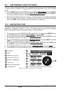
WAAS 3D
1
2
3
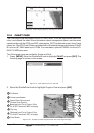
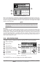
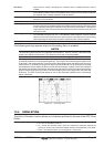
Figure 12.4 - Celestial page
Refer to the image above. The time (1) displayed corresponds to the location of the cross-
hair cursor (3) in the Tide Graph (2). Moving the ShuttlePoint knob to the left or right changes
the time, moving the ShuttlePoint knob up or down selects the Tide height and draught
(draft) on the Tide Graph.
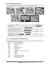
NOTE
The draught window shows the height of the tide water during a 24hr period of time. For example
if the ShuttlePoint knob is pressed up to move the cursor to the top of the Tide Graph this is the High
Water Level and if the cursor is moved to the bottom of the Tide Graph the draught will show the
Low Water Level.
Example 1
You anchor in 15 feet of water (under your keel) at a time of day where the water is the
highest (High Water). Let’s say the High Water window shows 5ft and the Low Water
window shows 1 foot this means the water under your vessel over a 24 hour period of time
could fall 4 feet (High Water - Low Water). With your vessel in 15 feet of water and with a
maximum water change of 4 feet during the day, the worst case situation there will be 11
feet of water under your vessel.
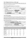
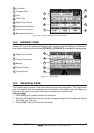
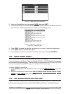
12.5 GPS STATUS PAGE
This page is used as a reference to see how well the GPS is receiving satellites.
WAAS 3D
Horizontal Dilution of Precision
4
2
Ship’s Coordinates
Tracked, but not used, Satellite
Used Satellite
1
6
3
Vertical Dilution of Precision
WAAS/GPS Icon
Date and Time
5
1
4
6
2
5
3
5
6
Used Satellite
6
COG (Course Over Ground)
7
D
C
E
A
B
7
14
20
25
31
28
Figure 12.5 - GPS Status page
The WAAS/GPS Icon area may change due to the satellite reception: