


Page 50 CPF180i and CPF300i
· Detailed Port Plan to information (complete port and marina charts with detail)
· Search & Find (quickly locates chart contents and objects)
· Tides Preview (allows viewing of current, future and past tide cycles of specific NOAA
Tide Stations)
· Dynamic Currents (current arrows showing speed and direction of current, future and
past currents)
· Dynamic Nav-Aids (selection to enable the Nav-Aids to blink to their specifications
and appear on the chart in color)
· Port Info (searchable data base of service in ports)
· Enhanced Port Info & Roads (searchable data base of detailed information that
include facilities and services in ports and surrounding areas)
· Object Info (moving cursor over object to show restricted area details and related
information)
· Quick Info (moving cursor over wrecks, shoals, Nav-Aids to show restricted area
details and related information and object to show details)
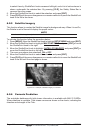
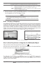
· Photos & Diagrams (high definition pictures of ports, piers, bridge diagrams and nav-
aids)
· Multilanguage Support (allows the plotter to show language of your choice in using
proper character set for Asian and other countries)
· True-Type Font (improves text on chart for optimal reading)
Presentation Features
· Clear View (advanced legibility techniques providing more chart data on the screen)
· Clear Info (sophisticated "Human Dictionary" to translate Nav-Aid abbreviations found
on paper charts)
· Flexi-Zoom (increased Under and Over Zoom between chart levels, resulting in
optimal scale display for any situation)
· Perspective View ("Real World" perspective view of the chart, updated real-time
during navigation)
· Enhanced Mixing Levels (seamless data presentation)
· Off-line redraw (cartography level transition without image construction)
Cartographic Data related Features
· Guardian Alarm (the Guardian Alarm is a user defined area in front of your vessel to
alert you while navigating of possible obstacles on the chart)
· Safety Toolbar (interactive alarm system for situational awareness on screen)
· Safety Route Check (sophisticated function that checks for dangerous objects along
your navigation route)
MAX and NT/NT
+
C-CARD coexistence
· When NT
+
data and MAX data cover different areas, the GPS Chart Plotter receives
data from both charts (depending on the current position).
· When NT
+
data and MAX data cover the same area, the GPS Chart Plotter receives
data only from MAX chart.