


CPF180i and CPF300i Page 85
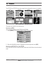
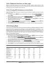
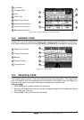
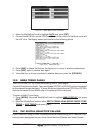
WAAS 3D
Time To Go
4
Fix position
2
7
Compass Tape
Time
1
6
3
8
Speed Over Ground
Course Over Ground
Bearing to Destination
5
1
3
4
2
5
6
8
7
Distance to Destination
Figure 12.2a - Navigation Data page with Compass Tape
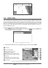
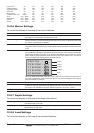
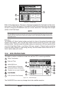
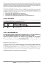
12.3 HIGHWAY PAGE
Shows a 3D view of the vessel travelling through the water when Navigating to a destination
point, Mark or following a Route. Press [ZOOM IN] or [ZOOM OUT] to change the highway scale.
WAAS 3D
Course over ground
4
2
1
3
Bearing
Speed Over Ground
Highway Display
Highway Scale
5
1
3
2
5
4
Figure 12.3 - Highway page
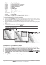
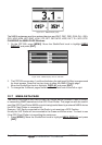
12.4 CELESTIAL PAGE
The Celestial page contains Tide information critical for safe navigation. This page is also
useful for boaters that are concerned about the height of the water under a bridge or by
fisherman that wish to know the tide and moon phase of a specific date.
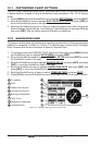
Changing date
1. Press [ENT] and a popup window will be shown.
2. Moving the ShuttlePoint knob up or down changes the digits and left and right selects
the month, day and year.
3. Press [CLR] to exit and view the information.