


Page 44 CPF180i and CPF300i
4.0.5 Lakes Information
This feature is used to locate Lakes nearest the position of your vessel.
An optional MAX Lake card must be inserted into the plotter to take advantage Lakes Information.
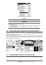
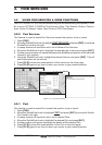
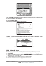
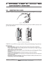
1. Press [FIND].
2. Move the ShuttlePoint knob to highlight
LAKES INFORMATION and press [ENT] or
move the ShuttlePoint knob to the right.
3. A popup window will be shown with a list of Outdoor Recreational Area objects.
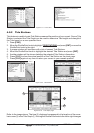
4. Move the ShuttlePoint knob to highlight the desired object and press [ENT].
5. Another popup window will appear displaying the distance and position of the Lakes
closest to your location.
6. Using the ShuttlePoint knob, highlight the desired Lake and press [ENT]. This will show
information on the Lake.
7. Press [CLR] to show the actual position of the Lake on the chart page.
8. Press [CLR] again at any time to return your cursor to your vessels position.
WAAS 3D
WAAS 3D
Figure 4.0.5 - Find Lakes Information
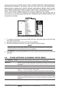
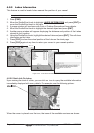
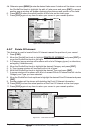
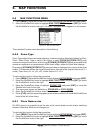
4.0.5.0 Quick Info On Lakes
Upon viewing the chart of a lake, you can click on icon to query the available information
immediately displayed with many details. For example, see the following picture:
Figure 4.0.5.0 - Example of Lakes info
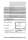
When the cursor is placed over the icon, the icons of the available services are shown: