


Page 54 CPF180i and CPF300i
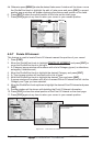
to select them by ShuttlePoint knob movement left/right, and a list of active alarms is
shown underneath the selected box. By pressing [CLR], the Safety Status Bar is
removed from the screen.
5. Move the ShuttlePoint knob to select the selection and press [ENT].
6. Press [CLR] until the menu disappears or an easier method is to press the ShuttlePoint
knob to the left a few times.
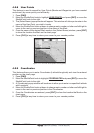
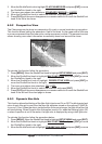
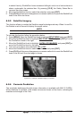
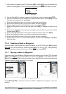
6.0.5 Satellite Imagery
This function allows to overlay the Satellite image for background map. When it is set On,
the Palette is set to Normal to display the proper colors.
NOTE
Note the satellite image is only shown on 100NM, 50NM and 20NM scales.
To activate this function follow the procedure below:
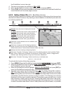
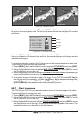
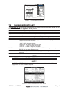
1. Press [MENU]. Move the ShuttlePoint knob to highlight
SETUP MENU and press [ENT].
2. Move the ShuttlePoint knob to highlight
MAX FUNCTIONS and press [ENT] or move
the ShuttlePoint knob to the right.
3. Move the ShuttlePoint knob to highlight
SATELLITE IMAGERY and press [ENT] or
move the ShuttlePoint knob to the right.
4. The menu now shows two selections,
ON or OFF.
5. Move the ShuttlePoint knob to select the selection and press [ENT].
6. Press [CLR] until the menu disappears or an easier method is to move the ShuttlePoint
knob to the left until the chart page is shown.
Figure 6.0.5 - Example of Satellite Imagery on CPF300i
6.0.6 Currents Prediction
The worldwide database with tidal stream information is available with MAX C-CARDs.
When data/time is available, Tidal stream arrows are shown on the charts, indicating the
direction and strength of the Tide: