


CPF180i and CPF300i Page 93
XTE Alarm : Alerts when the vessel is deviating from a defined course. Available selections: 0.00 to
9.99NM.
Depth Alarm : Alerts when the received depth Value from the optional FF520 50/200kHz BLACK BOX
FISH FINDER or Depth Finder inputting NMEA data into the GPS Chart Plotter is lower than
the selected value. Available selections: 0000 to 3000 FT.
Anchor Alarm : Alerts when the ships moves off a selected locations by a selected distance. Available
selections: 0.00 to 9.99NM.
Audible Alarm : Enables or disables the alarm beep.
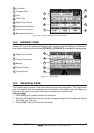
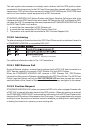
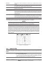
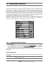
Grounding Alarm : This function looks ahead of the vessels heading to see if a potential danger exists. When
the Grounding Alarm is enabled the GPS Chart Plotter will draw a triangle in front of the vessel
on the Chart page showing the area that is being searched as shown below. The depth and
range (distance) of the area the GPS Chart Plotter looks ahead for a shallow area can be set
using this function.
Grounding Alarm Range : This function allows setting the distance of the grounding alarm zone (the length of the sector
to be detected) among the 0.25, 0.5, 1.0 Nm selections. When a depth or any of the searched
objects is found in the scanned area, a tick marker is printed on the relative box in the Grounding
Alarm Report page to identify which dangerous objects have been currently detected.
Grounding Alarm Report: This function allows displaying a report of the dangerous objects currently detected.
The following warning appears when the Grounding Alarm is enabled:
NOTES
The Grounding Alarm function only operates with the new NT
+
/MAX C-CARDs. It also affects the
speed of the redraw of the screen. If this function is not used it may be disabled.
When any of the objects checked are found for the first time, the GPS Chart Plotter shows a pop
up window to alert the user of the possible danger. The name of each new dangerous object found
is reported in the warning window. In the Grounding Alarm Report page the relative item has a tick
marker next to it, to identify the dangerous object currently detected. If in the next search cycle the
same objects are found again, the alarm window will not be shown. Instead, if in the next searches
the objects found before are no longer detected, their relevant item in the Grounding Alarm Report
page is cleared (note that in this case, if the same object type is found again later, the Alarm will
be shown). The GPS Chart Plotter shows an icon on the charts that identifies when a Grounding
Alarm is detected.
Figure 13.3 - Grounding Alarm
13.4 SIMULATION
The built-in Simulator function allows you to become proficient in the use of the GPS Chart
Plotter.
Simulation Mode : Three selections:
a. Off - turn the simulation mode off
b. On - enable the simulator mode, where the speed and course are adjusted by
entering in values in the Course and Speed selection discussed later in this table.
c. Route - this selection allows you to navigate to a saved route.