


CPF180i and CPF300i Page 91
13. ADVANCED SETTINGS
The Advanced Setup menu allows customization of many GPS functions, Alarms and
NMEA interfacing.
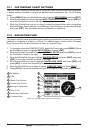
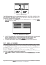
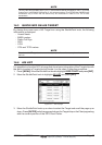
1. Press [MENU]. Move the ShuttlePoint knob to highlight
SETUP MENU and press [ENT].
2. Move the ShuttlePoint knob to highlight
ADVANCED SETUP and press [ENT] or move
the ShuttlePoint knob to the right.
While in this menu you will see many selections which are described in the next sections.
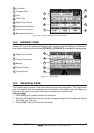
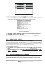
13.0 INPUT/OUTPUT (NMEA)
The CPF180i has 1 NMEA input and 2 NMEA outputs and the CPF300i has 3 inputs and
3 output connections.
These ports may be set up to receive and output the following.
· NMEA-0183 - NMEA devices set to 4800 Baud (default setting)
· C-Com - C-Weather refer to Section 15
· Radar - Sitex optional Radar refer to Radar Owner’s Manual
· AIS38400 - AIS Receiver, refer to Section 14
· Mobilarm - Mobil-arm receiver, refer to Section 16
· Disabled - allow the port to be disabled.
NOTE
When a port is configured, both the input and output have the same setting.
Radar is Port 1 is set to Radar, both the input and output wires are set to Sitex proprietary Radar
sentences. This means other devices should not be connected to the input or output wires.
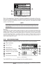
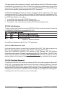
13.1 NAVIGATE
The Navigate Menu allows customization of the Coordinate System (Loran TD's), Map
Datum, Map Orientation Resolution (angle the vessel has to change before the chart is
redrawn) and Static Navigation. See the following table
Coordinate System : Selections are:
a. TD: Loran TD (see the following Par. 13.1.0)
b. UTM: Universal Transverse Mercator Grid
c. ddd mm.mmm:Degrees Minutes and Thousands of Minutes
d. ddd mm.mm: Degrees Minutes and Hundredths of Minutes
e. ddd mm.ss: Degrees Minutes and Seconds (default)
Map Datum : Allows selection of Map Datums. The default Datum is WGS84 as C-MAP B
Y JEPPESEN
cartography has been compiled using the WGS84 Datum. A datum is a mathematical
model of the Earth which approximates the shape of the Earth, and enables calculations
such as position and area to be carried out in a consistent and accurate manner.
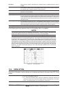
Map Orientation Resolution: Sets the angle the vessel has to change before the chart is redrawn. The default setting
is 30 degrees. Example: if the vessel is heading 000T at a speed of 25 Knots, the display
will redraw: