


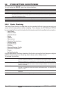


Page 78 CPF180i and CPF300i
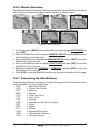
Figure 12b - Screen display pages (by Soft Keys) on CPF300i
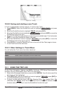
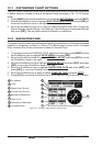
12.0 CHART PAGE
The Chart page is the main page of the GPS Chart Plotter. From this page the user can zoom
in/out, pan around the chart, show information about cartographic objects, see the exact
vessel position with the COG and SOG, place points, GOTO a destination point, show Track
history etc. The GPS Chart Plotter is provided with a Worldwide background showing C-MAP
B
Y JEPPESEN NT
+
/MAX detail up to 2.0 NM. For more detail, optional C-MAPBY JEPPESEN NT
+
/
MAX C-CARDs are used.
Two Chart page types are available: Single and Dual.
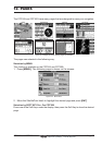
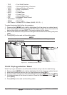
1. Press [MENU]. Move the ShuttlePoint knob to highlight
CHART and press [ENT].The
following page is shown on the screen:
Figure 12.0 - Chart selection menu on CPF300
2. Move the ShuttlePoint knob to highlight Single or Dual and press [ENT].
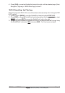
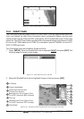
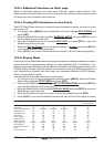
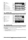
WAAS
Speed Over Ground and
Course Over Ground
4
Cursor coordinates
2
Fix Status
1
Bearings from Fix to Cursor (if the
Fix is NOT received, BRG is empty)
3
Chart Scale
7
4
3
2
1
5
6
7
5
6
Distance from Fix to Cursor (if the
Fix is NOT received, DST is empty)
Trip Log
Figure 12.0a - Example of Charts and general text area in the Single Chart page