


3-45190-00601-02 Rev. E
Garmin G600 Pilot’s Guide
Foreword
Sec 1
System
Sec 2
PFD
Sec 3
MFD
Sec 4
Hazard
Avoidance
Sec 5
Additional
Features
Sec 6
Annun.
& Alerts
Sec 7
Symbols
Sec 8
Glossary Appendix A
Appendix B
Index
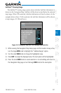
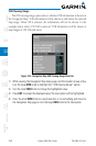
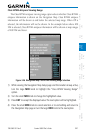
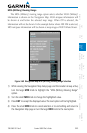
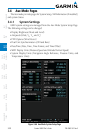
MOA (Military) Viewing Range
The MOA (Military) viewing range option selects whether MOA (Military)
information is shown on the Navigation Map. MOA airspace information will
be shown at and below the selected map range. When Off is selected, the
information will not be shown. In the example below where 200 NM is selected,
MOA airspace information will be shown at map ranges of 200 NM and lower.
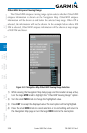
Figure 3-60 Navigation Map MOA (Military) Viewing Range Selection
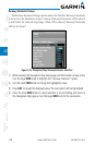
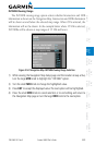
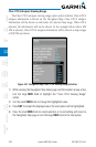
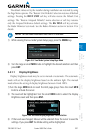
1) While viewing the Navigation Map Setup page and the Aviation Group active,
turn the large MFD knob to highlight the “
MOA (Military)
Viewing Range”
option.
2) Turn the small MFD knob to change the highlighted value.
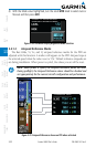
3) Press ENT
to accept the displayed value. The next option will be highlighted.
4) Press the small MFD knob to cancel selection or to end editing and return to
the Navigation Map page or turn the large MFD knob to the next option.