


3-1190-00601-02 Rev. E
Garmin G600 Pilot’s Guide
Foreword
Sec 1
System
Sec 2
PFD
Sec 3
MFD
Sec 4
Hazard
Avoidance
Sec 5
Additional
Features
Sec 6
Annun.
& Alerts
Sec 7
Symbols
Sec 8
Glossary Appendix A
Appendix B
Index
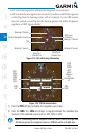
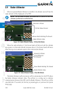
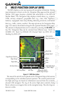
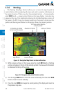
3 MULTI-FUNCTION DISPLAY (MFD)
The MFD displays a color moving map with navigation information. Moving
map information is shown on the two Navigation Map pages and the optional
Weather (WX) pages (requires a datalink and subscription or the GWX 68
Weather Radar).
The Navigation Map displays aviation data (e.g., airports,
VORs, airways, airspaces), geographic data (e.g., cities, lake, highways,
borders), topographic data (map shading indicating elevation), and hazard
data (e.g., traffic, terrain, weather). The map options set for Navigation Map
page 1 are used as the default settings for the optional Weather (WX) pages.
The amount of displayed data can be reduced by pressing the DCLTR soft
key. The Navigation Map can be oriented four different ways: North Up
(NORTH UP), Track Up (TRACK UP), Desired Track Up (DTK UP), or
Heading Up (HDG UP).
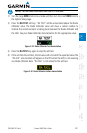
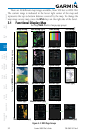
Map Orientation
Map Scale
Range Select
Menu
Clear
Enter
Small MFD Knob
(Select Page)
Large MFD Knob
(Select Page Group)
Soft KeysSoft Key Labels
SD Card Slots
Page Label
Page Group
Page Group Position
Wind Vector
Figure 3-1 MFD Description
The nose of the aircraft icon is placed on the Navigation Map at the location
corresponding to the calculated present position. The aircraft position and
the flight plan legs are based on information received from the currently
selected GPS navigator. The leg of the active flight plan currently being
flown is shown as a magenta line on the navigation map. The other legs are
shown in white.