


3-80
Garmin G600 Pilot’s Guide
190-00601-02 Rev. E
Foreword
Sec 1
System
Sec 2
PFD
Sec 3
MFD
Sec 4
Hazard
Avoidance
Sec 5
Additional
Features
Sec 6
Annun.
& Alerts
Sec 7
Symbols
Sec 8
GlossaryAppendix A
Appendix B
Index
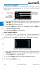
4) Press ENT to activate the selected value.
In dual installations, the minimums alerting altitude value may be set from
either GDU 620 and will be synchronized on both units.
NOTE:
If you highlight the Minimums Altitude field on the FPL page and
press the CLR key, it will turn the minimums functionality off.
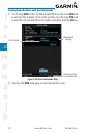
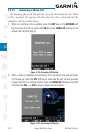
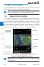
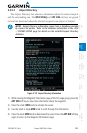
3.5.2 Waypoint Information Page
The Waypoint Information page provides details about a particular waypoint.
You can show a waypoint by selecting it by Ident, Facility Name, or by City. The
Map window shows the selected waypoint in the center of the map. The Range
keys zoom in and out on the map. The Info window at the bottom of the display
shows the Bearing and Distance from your present position to the selected
waypoint as well as its region and Lat/Lon coordinates. The map window is set
up with the same parameters as were selected for Navigation Map Page 1.
Facility Type
Map Window
Map Region
Lat/Lon
Map Scale
Map Orientation
Bearing & Distance
to Wpt from
Present Position
Rwy/Freq Soft Key
Airport Directory Soft Key
Facility Identifier
Facility Name
Facility Location
Wpt Weather Info Soft Key
Figure 3-114 Flight Plan Waypoint Information Page
NOTE: Waypoint information is shown on the second page of the Flight
Plan page group.