


4-107190-00601-02 Rev. E
Garmin G600 Pilot’s Guide
Foreword
Sec 1
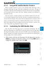
System
Sec 2
PFD
Sec 3
MFD
Sec 4
Hazard
Avoidance
Sec 5
Additional
Features
Sec 6
Annun.
& Alerts
Sec 7
Symbols
Sec 8
Glossary Appendix A
Appendix B
Index
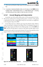
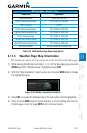
WX Page Menu - Weather Setup
Menu Item Adjustment
Map Orientation North Up, Track Up
PRECIP Data Viewing Range Off, 50 NM to 2000 NM
PRECIP Legend On/Off
IR SAT Data Viewing Range Off, 50 NM to 2000 NM
Lightning Data Viewing Range Off, 50 NM to 2000 NM
SIG/Air Viewing Range Off, 50 NM to 2000 NM
METAR Data Viewing Range Off, 50 NM to 2000 NM
Wnd Aloft Data Viewing Range Off, 50 NM to 2000 NM
Wnd Aloft Altitude Surface, 3000 feet to 42000 feet
Table 4-24 GFDS Weather Page Menu Setup Options
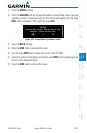
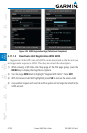
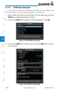
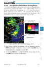
4.11.4 Weather Page Map Orientation
The Orientation option sets the orientation of the Wx Data Link Map pages.
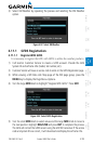
1) While viewing the Wx Data Link Map 1, 2, or 3 of the Wx page group, press the
MENU key. With “Weather Setup” highlighted, press ENT.
2) With the “Map Orientation” option active, turn the small MFD knob to change
the highlighted value.
Figure 4-98 Weather Page Map Orientation
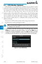
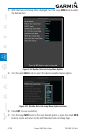
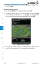
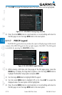
3) Press ENT
to accept the displayed value. The next option will be highlighted.
4) Press the small MFD knob to cancel selection or to end editing and return to
the WX page or turn the large MFD knob to the next option.