


4-10
Garmin G600 Pilot’s Guide
190-00601-02 Rev. E
Foreword
Sec 1
System
Sec 2
PFD
Sec 3
MFD
Sec 4
Hazard
Avoidance
Sec 5
Additional
Features
Sec 6
Annun.
& Alerts
Sec 7
Symbols
Sec 8
GlossaryAppendix A
Appendix B
Index
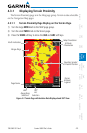
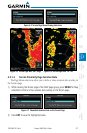
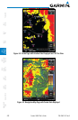
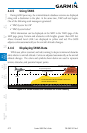
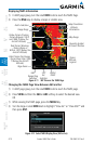
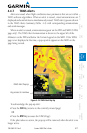
4.4 Terrain Awareness and Warning System
(TAWS-B) Optional
TAWS (Terrain Awareness and Warning System) is an optional feature to
increase situational awareness and aid in reducing controlled flight into terrain
(CFIT). TAWS provides visual and aural annunciations when terrain and
obstacles are within the given altitude threshold from the aircraft. The displayed
alerts and warnings are advisory in nature only.
TAWS satisfies TSO-C151b Class B requirements for certification. Class B
TAWS is required for all Part 91 turbine aircraft operations with six or more
passenger seats and for Part 135 turbine aircraft operations with six to nine
passenger seats (FAR Parts 91.223, 135.154).
4.4.1 TAWS-B Requirements
TAWS requires the following to operate properly:
•Avalidterrain/obstacle/airportterraindatabase
•Avalid3-DGPSpositionsolution
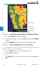
4.4.2 TAWS-B Limitations
NOTE: The data contained in the TAWS databases comes from government
agencies. Garmin accurately processes and cross-validates the data but
cannot guarantee the accuracy and completeness of the data.
TAWS displays terrain and obstructions relative to the altitude of the aircraft.
Compliance with TAWS B alerts and warnings is MANDATORY. When a TAWS
B "pull up" annunciation is issued, the pilot is required to pull up.
TAWS uses terrain and obstacle information supplied by government sources.
Terrain information is based on terrain elevation information in a database that
may contain inaccuracies. Individual obstructions may be shown if available in
the database. The data undergoes verification by Garmin to confirm accuracy of
the content, per TSO-C151b.