


4-14
Garmin G600 Pilot’s Guide
190-00601-02 Rev. E
Foreword
Sec 1
System
Sec 2
PFD
Sec 3
MFD
Sec 4
Hazard
Avoidance
Sec 5
Additional
Features
Sec 6
Annun.
& Alerts
Sec 7
Symbols
Sec 8
GlossaryAppendix A
Appendix B
Index
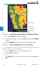
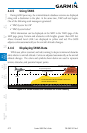
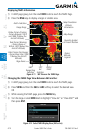
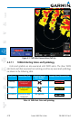
Displaying TAWS Information
1) In MAP page group, turn the small MFD knob to reach the TAWS Page.
2) Press the RNG keys to display a larger or smaller area.
Map Orientation
North Indication
Range Rings
Altitude
Information
Terrain
Altitude
Legend
Ownship Symbol
at Present Position
360°
Range Ring
Selection
120°
Arc
Selection
Page Name
Inhibit
TAWS
Black Terrain (No Danger
- Terrain More than 1000
ft Below the Aircraft
Altitude)
Yellow Terrain (Caution
- Terrain Between 100 ft
and 1000 ft Below the
Aircraft Altitude)
Map Range
Red Terrain (Warning
- Terrain Above or
Within 100 ft Below the
Aircraft Altitude)
Figure 4-11 360˚ View on the TAWS Page
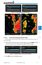
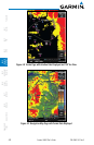
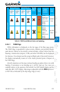
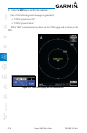
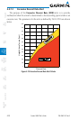
Changing the TAWS Page View Between 360 and Arc
1) In MAP page group, turn the small MFD knob to reach the TAWS page.
2) Press VIEW and then the 360 or ARC soft key to select the desired view.
OR
1) While viewing the TAWS page, press the MENU key.
2) Turn the large or small MFD knob to highlight “View Arc” or “View 360°” and
then press ENT.
Figure 4-12 Select TAWS Display View (360 or Arc)