


3-10
Garmin G600 Pilot’s Guide
190-00601-02 Rev. E
Foreword
Sec 1
System
Sec 2
PFD
Sec 3
MFD
Sec 4
Hazard
Avoidance
Sec 5
Additional
Features
Sec 6
Annun.
& Alerts
Sec 7
Symbols
Sec 8
GlossaryAppendix A
Appendix B
Index
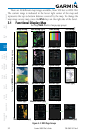
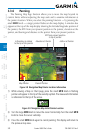
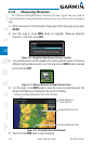
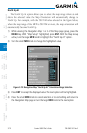
3.3.8 Measuring Distances
The “Measure Bearing/Distance” function provides a quick and easy method
to determine the bearing and distance between any two points on the Navigation
Map.
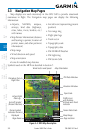
1) While viewing one of the Navigation Map pages of the Map page group, press
MENU.
2) Turn the
large
or small MFD knobs to highlight “Measure Bearing/
Distance“ and then press
ENT
.
Figure 3-10 Navigation Map Measure Distance Function
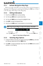
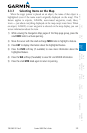
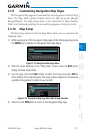
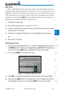
3) Your present position will be marked as the starting reference point. To choose a
different starting reference point, turn the large or small MFD knobs to desired
point and press ENT.
Figure 3-11 Measure Distance Starting Reference Point
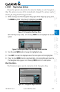
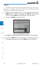
4) Turn the large or small MFD knobs to move the cursor to a reference point. The
distance and bearing is displayed at the top of the display.
Ending Reference
Point position
Ending Reference Point
Starting Reference Point
Distance and Bearing Between Start and End Points
Figure 3-12 Bearing/Distance Measurement
5) Press the small MFD knob to stop measuring.