


4-102
Garmin G600 Pilot’s Guide
190-00601-02 Rev. E
Foreword
Sec 1
System
Sec 2
PFD
Sec 3
MFD
Sec 4
Hazard
Avoidance
Sec 5
Additional
Features
Sec 6
Annun.
& Alerts
Sec 7
Symbols
Sec 8
GlossaryAppendix A
Appendix B
Index
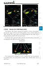
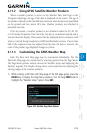
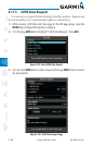
4.11 GFDS Weather (Optional)
GFDS Weather is an optional feature available with the Iridium
®
satellite
system that is interfaced through the optional Garmin GSR 56. The primary maps
for viewing Garmin Flight Data System (GFDS) Weather data are the Weather
Data Link Pages in the Map Page Group. These are the only GDU 620 map
displays capable of all available GFDS weather products. The Wx Weather pages
may be oriented to either Track Up or North Up. Both GFDS and XM Weather
may be installed and selected individually. Coverage is available throughout
most of Europe, Canada and the U.S. Additional radar coverage areas are being
added continuously.
More detail on GFDS weather products and coverage can be found at:
http://fly.garmin.com/fly-garmin/gfds-weather/
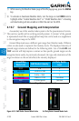
NOTE: A system can be configured for both XM and GFDS, but both cannot
be displayed a the same time.
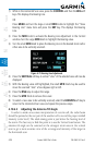
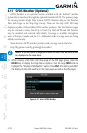
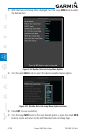
1) While viewing a WX Data Link Map page of the WX page group, press the
MENU key to display the Page
Menu Options
. Turn the large MFD knob to
highlight the “Display GFDS Weather” option. Press
ENT
.
This setting will affect
the display of data link weather on the map pages as well as the Wx pages.
Figure 4-91 Select GFDS Weather