


1-4
Garmin G600 Pilot’s Guide
190-00601-02 Rev. E
Foreword
Sec 1
System
Sec 2
PFD
Sec 3
MFD
Sec 4
Hazard
Avoidance
Sec 5
Additional
Features
Sec 6
Annun.
& Alerts
Sec 7
Symbols
Sec 8
GlossaryAppendix A
Appendix B
Index
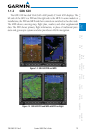
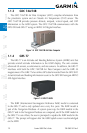
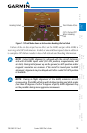
1.1.3 GDC 74A/74B
The GDC 74A/74B Air Data Computer (ADC) compiles information from
the pitot/static system and an Outside Air Temperature (OAT) sensor. The
GDC 74A/74B provides pressure altitude, airspeed, vertical speed, and OAT
information to the G600 system. The GDC 74A/74B communicates with the
GDU 620 and GRS 77 using an ARINC 429 digital interface.
Figure 1-4 GDC 74A/74B Air Data Computer
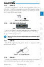
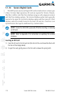
1.1.4 GRS 77
The GRS 77 is an Attitude and Heading Reference System (AHRS) unit that
provides aircraft attitude information to the G600 display. The unit contains
advanced tilt sensors, accelerometers, and rate sensors. In addition, the GRS 77
interfaces with both the GDC 74A/74B Air Data Computer and the GMU 44
magnetometer. The GRS 77 also utilizes GPS data forwarded from the GDU 620.
Actual attitude and heading information is sent to the GDU 620 using an ARINC
429 digital interface.
Figure 1-5 GRS 77 AHRS
The IGRF (International Geomagnetic Reference Field) model is contained
in the GRS 77 and is only updated once every five years. The IGRF model is
part of the Navigation Database. At system power-up, the IGRF models in the
GRS 77 and in the Navigation Database are compared, and if the IGRF model in
the GRS 77 is out of date, the user is prompted to update the IGRF model in the
GRS 77. The prompt will appear after the G600 splash screen is acknowledged
on the MFD.