


3-16
Garmin G600 Pilot’s Guide
190-00601-02 Rev. E
Foreword
Sec 1
System
Sec 2
PFD
Sec 3
MFD
Sec 4
Hazard
Avoidance
Sec 5
Additional
Features
Sec 6
Annun.
& Alerts
Sec 7
Symbols
Sec 8
GlossaryAppendix A
Appendix B
Index
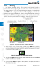
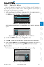
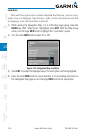
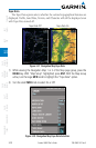
Land Data
The Land Data option selects whether detailed land features, such as rivers,
roads, cities, are displayed. Topo features, traffic, terrain, and obstacles will still
be displayed, even with Land Data turned off.
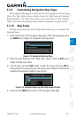
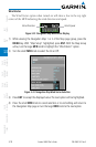
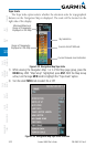
1) While viewing the Navigation Map 1 or 2 of the Map page group, press the
MENU key. With “Map Setup” highlighted, press ENT. With the Map Group
active, turn the large MFD knob to highlight the “Land Data” option.
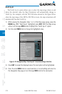
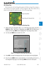
2) Turn the small MFD knob to select On or Off.
Figure 3-20 Navigation Map Land Data
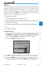
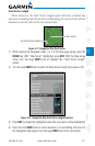
3) Press ENT
to accept the displayed value. The next option will be highlighted.
4) Press the small MFD knob to cancel selection or to end editing and return to
the Navigation Map page or turn the large MFD knob to the next option.