


4-72
Garmin G600 Pilot’s Guide
190-00601-02 Rev. E
Foreword
Sec 1
System
Sec 2
PFD
Sec 3
MFD
Sec 4
Hazard
Avoidance
Sec 5
Additional
Features
Sec 6
Annun.
& Alerts
Sec 7
Symbols
Sec 8
GlossaryAppendix A
Appendix B
Index
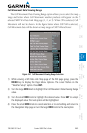
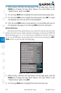
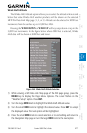
1) While viewing a WX Data Link Map page of the WX page group, press the
MENU key to display the Page
Menu Options
. The cursor flashes on the
“Weather Setup” option. Press ENT
.
2) Turn the large MFD knob to highlight the Surface Data Viewing Range value.
3) Turn the small MFD knob to highlight the desired value. Press ENT
to accept
the displayed value. The next option will be highlighted.
4) Press the small MFD knob to cancel selection or to end editing and return to
the Navigation Map page or turn the large MFD knob to the next option.
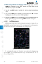
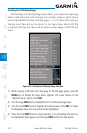
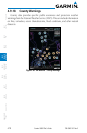
Surface Data Time
The Surface Data Time option allows you to select the forecast time when the
Surface and City Forecast weather products will appear on the selected MFD Wx
Data Link Map page (1, 2, or 3). Forecasts are available for intervals of current,
12, 24, 36, and 48 hours. You may also select an interval by pressing the SRFC
TIME soft key on the Wx Data Link Map page.
Figure 4-58 Surface Data Time Selection
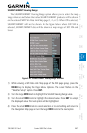
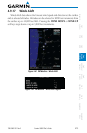
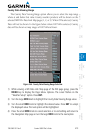
1) While viewing a WX Data Link Map page of the WX page group, press the
MENU key to display the Page
Menu Options
. The cursor flashes on the
“Weather Setup” option. Press ENT
.
2) Turn the large MFD knob to highlight the Surface Data Time value.