


4-32
Garmin G600 Pilot’s Guide
190-00601-02 Rev. E
Foreword
Sec 1
System
Sec 2
PFD
Sec 3
MFD
Sec 4
Hazard
Avoidance
Sec 5
Additional
Features
Sec 6
Annun.
& Alerts
Sec 7
Symbols
Sec 8
GlossaryAppendix A
Appendix B
Index
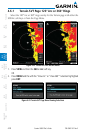
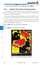
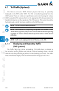
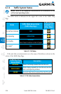
4.7 TAS Traffic (Optional)
TAS refers to an active Traffic Adivsory System that may be optionally
displayed on the PFD and/or MFD. The TAS is installed separately from the
G600 system. There are variations in performance and control among the various
G600-compatible TAS systems. Refer to the appropriate TAS documentation for
detailed information on the operation of the TAS system. This section describes
the display and control functions available on the G600 system.
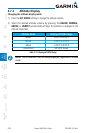
NOTE: TIS and TAS are mutually exclusive.
NOTE: Aircraft without an operating transponder are invisible to both
Traffic Advisory Systems (TAS) and TIS. Aircraft without altitude reporting
capability are shown without altitude separation data or climb descent
indication.
NOTE: Traffic is also displayed in the SVT feature on the PFD.
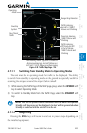
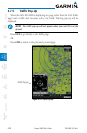
4.7.1 Displaying and Operating Traffic
(TAS Systems)
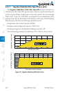
The Traffic Map Page shows surrounding TAS traffic data in relation to
the aircraft’s current position and altitude without basemap clutter. Aircraft
orientation is always heading up unless no valid heading is received. The traffic
mode and altitude display mode are annunciated in the upper left corner.