


xiii190-00601-02 Rev. E
Garmin G600 Pilot’s Guide
Forward
Sec 1
System
Sec 2
PFD
Sec 3
MFD
Sec 4
Hazard
Avoidance
Sec 5
Additional
Features
Sec 6
Annun.
& Alerts
Sec 7
Symbols
Sec 8
Glossary Appendix A
Appendix B
Index
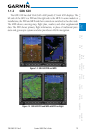
4.11.8 GFDS Infrared Satellite (IR SAT) Data Viewing Range ..........4-115
4.11.9 Data Link Lightning (DL LTNG) Data Viewing Range............4-117
4.11.10 SIGMETs and AIRMETs (SIG/AIR) ........................................4-119
4.11.11 METARs ............................................................................4-122
4.11.12 Winds Aloft .......................................................................4-124
5 Additional Features (Optional) ............................................................5-1
5.1 Viewing Charts .....................................................................................5-2
5.1.1 Chart Panning .......................................................................5-3
5.1.2 Choosing a Chart for the Current Airport ................................5-4
5.1.3 Selecting a Chart by Identifier ................................................5-6
5.1.4 Selecting a New Chart by FPL, NRST, or RECENT .....................5-7
5.1.5 Charts Menu Selections .........................................................5-7
5.1.5.1 Setting the Altitude Minimums Alerter ....................................5-8
5.1.5.2 Viewing Chart NOTAMs .........................................................5-9
5.1.5.3 Day/Night View .....................................................................5-9
5.2 ChartView (Optional) ..........................................................................5-10
5.2.1 Cycle Number and Revision .................................................5-11
5.2.2 Viewing Chart Details in ChartView .....................................5-13
5.3 FliteCharts
®
.......................................................................................5-16
5.3.1 Cycle Number and Revision .................................................5-16
5.4 SafeTaxi
®
..........................................................................................5-18
5.4.1 Using SafeTaxi
®
.................................................................5-19
5.4.1.1 Decluttering ........................................................................5-19
5.4.1.2 Hot Spot Information ...........................................................5-19
5.4.2 SafeTaxi
®
Cycle Number and Revision ..................................5-20
5.5 XM
®
Radio Entertainment ..................................................................5-22
5.5.1 Activating XM
®
Satellite Radio Services ................................5-22
5.5.2 XM
®
Information .................................................................5-24
5.5.3 XM
®
Entertainment Radio ...................................................5-25
5.5.3.1 Channel Categories .............................................................5-26
5.5.3.2 Selecting an XM
®
Radio Channel .........................................5-27
5.5.3.3 XM
®
Radio Volume ..............................................................5-28
5.5.3.4 XM
®
Radio Channel Presets .................................................5-29
5.5.4 GDL 69/69A Data Link Receiver Troubleshooting ..................5-30
5.6 Autopilot Operation ............................................................................5-31
5.6.1 Autopilot Test ......................................................................5-31
5.6.2 Heading ..............................................................................5-32
5.6.3 Altitude Capture (Optional Interface) ...................................5-32