


1-13190-00601-02 Rev. E
Garmin G600 Pilot’s Guide
Foreword
Sec 1
System
Sec 2
PFD
Sec 3
MFD
Sec 4
Hazard
Avoidance
Sec 5
Additional
Features
Sec 6
Annun.
& Alerts
Sec 7
Symbols
Sec 8
Glossary Appendix A
Appendix B
Index
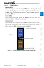
1.3 International Geomagnetic Reference Field
The IGRF (International Geomagnetic Reference Field) model is contained in
the GRS 77 and is only updated once every five years. The IGRF model is part of
the Navigation Database. At system power-up, the IGRF models in the GRS 77
and in the Navigation Database are compared, and if the IGRF model in the GRS
77 is out of date, the user is prompted to update the IGRF model in the GRS 77.
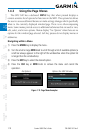
The following prompt will appear after the G600 splash screen is acknowledged
on the MFD.
GRS MV DB UPDATE AVAILABLE.UPDATE FROM yyyy TO yyyy
(e.g. 2005 to 2010)
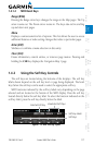
Pressing the ENT key (or right-most soft key) acknowledges this information
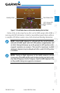
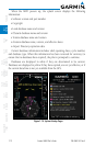
and displays the Navigation Map Page. When the interfaced GPS unit has
acquired a sufficient number of satellites to determine a position, the aircraft’s
current position is shown on the Navigation Map Page.