


4-54
Garmin G600 Pilot’s Guide
190-00601-02 Rev. E
Foreword
Sec 1
System
Sec 2
PFD
Sec 3
MFD
Sec 4
Hazard
Avoidance
Sec 5
Additional
Features
Sec 6
Annun.
& Alerts
Sec 7
Symbols
Sec 8
GlossaryAppendix A
Appendix B
Index
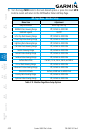
2) An abbreviated legend may be displayed on the upper right side of a WX Data
Link Map page for the applicable weather products when selected in the Page
Menu options for Weather.
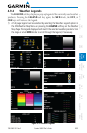
4.9.5 NEXRAD
WSR-88D, or NEXRAD (NEXt-generation RADar), is a network of 158 high-
resolution Doppler radar systems that are operated by the National Weather
Service (NWS). NEXRAD data provides centralized meteorological information
for the continental United States and selected overseas locations. The maximum
range of a single NEXRAD radar site is 250 NM. The NEXRAD network provides
important information about severe weather for air traffic safety. Canadian Radar
provided by Environment Canada.
NEXRAD data is not real-time. The lapsed time between collection, processing,
and dissemination of NEXRAD images can be significant and may not reflect
the current radar synopsis. Due to the inherent delays and the relative age of
the data, it should be used for long-range planning purposes only. Never use
NEXRAD data or any radar data to penetrate hazardous weather. Instead, use it
in an early-warning capacity of pre-departure and en route evaluation.
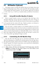
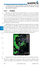
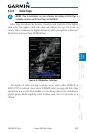
Figure 4-35 XM Weather - NEXRAD
Composite data from all the NEXRAD radar sites in the United States is shown.
This data is composed of the maximum reflectivity from the individual radar
sweeps. The display of the information is color-coded to indicate the weather