


4-124
Garmin G600 Pilot’s Guide
190-00601-02 Rev. E
Foreword
Sec 1
System
Sec 2
PFD
Sec 3
MFD
Sec 4
Hazard
Avoidance
Sec 5
Additional
Features
Sec 6
Annun.
& Alerts
Sec 7
Symbols
Sec 8
GlossaryAppendix A
Appendix B
Index
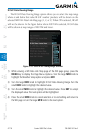
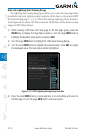
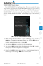
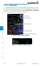
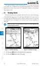
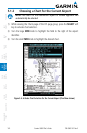
4.11.12 Winds Aloft
Winds Aloft data shows the forecast wind speed and direction at the surface
and at selected altitudes. Altitudes can be selected in 3000 foot increments from
the surface up to 42,000 feet MSL. Pressing the WIND DOWN or WIND UP
soft keys steps down or up in 3,000 foot increments.
Present Position
Product Age
Winds Aloft Altitude Soft Keys
Winds Aloft Symbol
Selected Altitude
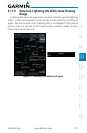
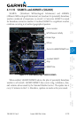
Figure 4-118 GFDS Weather - Winds Aloft
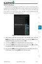
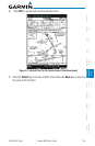
Figure 4-119 GFDS Weather - Winds Aloft Legend