


xiv
Garmin G600 Pilot’s Guide
190-00601-02 Rev. E
Foreword
Sec 1
System
Sec 2
PFD
Sec 3
MFD
Sec 4
Hazard
Avoidance
Sec 5
Additional
Features
Sec 6
Annun.
& Alerts
Sec 7
Symbols
Sec 8
GlossaryAppendix A
Appendix B
Index
5.6.4 Autopilot Navigation ...........................................................5-33
5.6.4.1 Autopilot Operation with GPSS Enabled Autopilots ...............5-33
5.6.4.2 Autopilot Operation with the GDU 620 Emulating GPSS .......5-34
5.6.5 Flight Director Display ..........................................................5-35
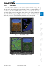
5.7 Synthetic Vision Technology (Optional) (SVT™) ....................................5-36
5.7.1 SVT™ Operation .................................................................5-38
5.7.2 Activating and Deactivating SVT™ ......................................5-39
5.7.3 SVT™ Features ...................................................................5-40
5.7.3.1 Flight Path Marker (FPM) .....................................................5-40
5.7.3.2 Zero-Pitch Line ....................................................................5-40
5.7.3.3 Horizon Heading .................................................................5-41
5.7.3.4 Airport Signs .......................................................................5-41
5.7.3.5 Runway Depiction ...............................................................5-42
5.7.3.6 Traffic ..................................................................................5-43
5.7.3.7 Obstacles ............................................................................5-44
5.7.3.8 Field of View .......................................................................5-45
5.7.3.9 Unusual Attitudes ................................................................5-47
6 Annunciations and Alerts .....................................................................6-1
6.1 Alerts ...................................................................................................6-1
6.2 System Status .......................................................................................6-9
7 Symbols ................................................................................................7-1
7.1 Map Page Symbols ................................................................................7-1
7.2 SafeTaxi
™ Symbols .............................................................................7-2
7.3 Traffic Symbols ......................................................................................7-2
7.4 Terrain Obstacle Symbols .......................................................................7-3
7.5 Basemap Symbols .................................................................................7-4
7.6 Map Tool Bar Symbols ...........................................................................7-4
7.7 XM Weather Tool Bar Symbols ...............................................................7-5
7.8 Miscellaneous Symbols ..........................................................................7-6
8 Glossary ...............................................................................................8-1
Appendix A ................................................................................................. A-1
SD Card Use and Databases ..........................................................................A-1
Jeppesen Databases ...............................................................................A-2
Updating the Jeppesen Database............................................................A-2
Garmin Databases ..................................................................................A-4
Updating Garmin Databases ...................................................................A-5
Index ........................................................................................................... B-1