


3-77190-00601-02 Rev. E
Garmin G600 Pilot’s Guide
Foreword
Sec 1
System
Sec 2
PFD
Sec 3
MFD
Sec 4
Hazard
Avoidance
Sec 5
Additional
Features
Sec 6
Annun.
& Alerts
Sec 7
Symbols
Sec 8
Glossary Appendix A
Appendix B
Index
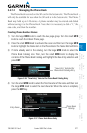
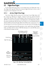
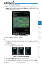
3.5 Flight Plan Pages
Use the Flight Plan page group to view details about your flight plan route.
The Flight Plan Function shows the Current Flight Plan that is active in the
navigation source displayed on the CDI.
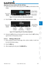
3.5.1 Active Flight Plan Page
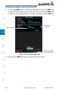
The Active Flight Plan box shows all of the legs of your flight plan with
the current leg indicated in magenta. Listed are each leg with the Desired
Track (DTK), Distance (DIS), and Estimated Time of Arrival (ETA) for the legs.
METARs are shown for waypoints in the flight plan. In the Minimums window,
the source and selected value are shown. See section 2.4.4 on Minimum Descent
Altitude (MDA) or Decision Height (DH) in the PFD section and section 3.5.1.3
for more detail. In the Active Leg Info box in the lower part of the display, the
Course with beginning and ending waypoints, Active Leg En Route Safe Altitude
(ESA), and Route ESA are shown. METAR information is in the METAR section
of the Hazard Avoidance section.
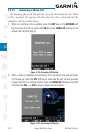
Current Leg
Flight Plan Legs
Graphic METARs
Active Leg
Window
DTK, Distance, and ETA
from the Previous Leg
Baro
Minimums
Window
Digital Chart
Available
For Waypoint
Figure 3-108 Flight Page 1 (Active Flight Plan)