


4-11190-00601-02 Rev. E
Garmin G600 Pilot’s Guide
Foreword
Sec 1
System
Sec 2
PFD
Sec 3
MFD
Sec 4
Hazard
Avoidance
Sec 5
Additional
Features
Sec 6
Annun.
& Alerts
Sec 7
Symbols
Sec 8
Glossary Appendix A
Appendix B
Index
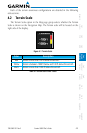
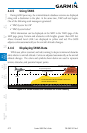
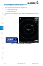
4.4.3 Computing GPS Altitude for TAWS
TAWS uses information provided from the GPS receiver to provide a horizontal
position and altitude. GPS altitude is derived from satellite measurements.
GPS altitude is converted to a Mean Sea Level (MSL)-based altitude (GPS-MSL
altitude) and is used to determine TAWS alerts. GPS-MSL altitude accuracy is
affected by factors such as satellite geometry, but it is not subject to variations
in pressure and temperature that normally affect pressure altitude devices. GPS-
MSL altitude does not require local altimeter settings to determine MSL altitude.
Therefore, GPS altitude provides a highly accurate and reliable MSL altitude
source to calculate terrain and obstacle alerts.
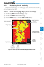
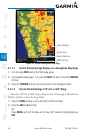
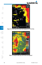
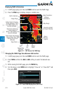
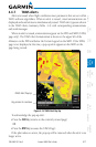
The terrain and obstacle databases used by TAWS are referenced to Mean
Sea Level. Using the GPS position and GPS-MSL altitude, TAWS displays a 2-D
(or 3-D with SVT) picture of the surrounding terrain and obstacles relative to
the position and altitude of the aircraft. Furthermore, the GPS position and
GPS-MSL altitude are used to calculate and “predict” the aircraft’s flight path
in relation to the surrounding terrain and obstacles. In this manner, TAWS can
provide advanced alerts of predicted dangerous terrain conditions.
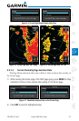
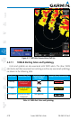
4.4.4 Baro-Corrected Altitude Versus GPS-MSL
Altitude
Baro-corrected altitude (or indicated altitude) is derived by adjusting the
altimeter setting for local atmospheric conditions. The most accurate baro-
corrected altitude can be achieved by frequently updating the altimeter setting
to the nearest reporting station along the flight path. However, because actual
atmospheric conditions seldom match the standard conditions defined by the
International Standard Atmosphere (ISA) model (where pressure, temperature,
and lapse rates have fixed values), it is common for the baro-corrected altitude
(as read from the altimeter) to differ from the GPS-MSL altitude. This variation
results in the aircraft’s true altitude differing from the baro-corrected altitude.