


190-01255-00 Rev. B
Garmin G1000H
™
Pilot’s Guide for the Bell 407GX
155
FLIGHT MANAGEMENT
MAP SYMBOLS
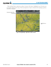
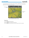
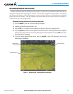
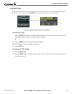
This section discusses the types of land and aviation symbols that can be displayed. Each listed type of symbol
can be turned on or off, and the maximum range to display each symbol can be set. The decluttering of the
symbols from the map using the DCLTR Softkey is also discussed.
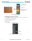
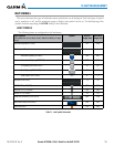
LAND SYMBOLS
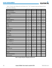
The following items are configured on the land menu:
Land Symbols
(Text label size can be None, Small, Medium (Med), or Large
(Lrg))
Symbol Default
Range (nm)
Maximum
Range (nm)
Latitude/Longitude (LAT/LON) Off 2000
Highways and Roads
Interstate Highway (FREEWAY) 300 800
International Highway (FREEWAY) 300 800
US Highway (NATIONAL HWY) 30 80
State Highway (LOCAL HWY) 15 30
Local Road (LOCAL ROAD) N/A 8 15
Railroads (RAILROAD) 15 30
LARGE CITY (> 200,000) 800 1500
MEDIUM CITY (> 50,000) 100 200
SMALL CITY (> 5,000) 20 50
States and Provinces (STATE/PROV) 800 1500
Rivers and Lakes (RIVER/LAKE) 200 500
USER WAYPOINT 150 300
Table 5-1 Land Symbol Information