


190-01255-00 Rev. B
Garmin G1000H
™
Pilot’s Guide for the Bell 407GX
351
HAZARD AVOIDANCE
6.4 TRAFFIC INFORMATION SERVICE (TIS)
WARNING
: The Traffic Information Service (TIS) is intended for advisory use only. TIS is intended to help the
pilot locate traffic visually. It is the responsibility of the pilot to see and maneuver to avoid traffic.
NOTE: TIS is available only when the aircraft is within the service volume of a TIS-capable terminal radar
site. Aircraft without an operating transponder are invisible to both Traffic Advisory Systems (TAS) and TIS.
Aircraft without altitude reporting capability are shown without altitude separation data or climb descent
indication.
NOTE: TIS is disabled if a Traffic Advisory System (TAS) is installed.
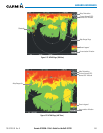
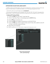
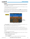
TrafcInformationService(TIS)isdesignedtohelpindetectionandavoidanceofotheraircraft.TISusesthe
ModeStransponderforthetrafcdatalink.TISreceivestrafcinformationfromgroundstations,andisupdated
every5seconds.TheG1000Hdisplaysuptoeighttrafctargetswithina7.5-nmradius,from3000feetbelowto
3500feetabovetherequestingaircraft.Trafcisdisplayedusingthreedifferentsymbols(Table6-12).
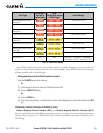
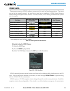
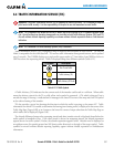
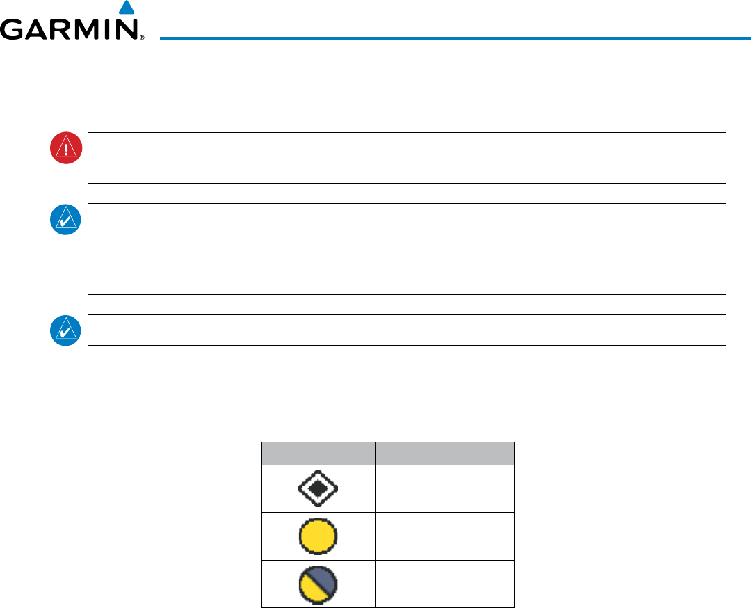
TIS Symbol Description
Non-Threat Traffic
Traffic Advisory (TA)
Traffic Advisory Off Scale
Table 6-12 TIS Traffic Symbols
ATrafcAdvisory(TA)indicatesthatthecurrenttrackoftheintrudercouldresultinacollision.Whentrafc
meetstheadvisorycriteriafortheTA,asolidyellowcirclesymbolisgenerated.ATAwhichisdetected,butis
outsidetherangeofthemap,isindicatedwithamessageinthelowerleftcornerofthemapandahalfTAsymbol
attherelativebearingoftheintruder.
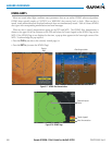
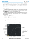
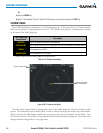
TISalsoprovidesavectorlineshowingthedirectioninwhichthetrafcismoving,tothenearest45°.Trafc
informationforwhichTISisunabletodeterminethebearing(non-bearingtrafc)isdisplayedinthecenterofthe
TrafcMapPage(Figure6-88)orinabanneratthelowerleftcornerofmapsotherthantheTrafcMapPageon
whichtrafccanbedisplayed(Figure6-84).
Thealtitudedifferencebetweentherequestingaircraftandotherintruderaircraftisdisplayedabove/belowthe
trafcsymbolinhundredsoffeet.Iftheotheraircraftisabovetherequestingaircraft,thealtitudeseparation
appearsabovethetrafcsymbol;ifbelow,thealtitudeseparationappearsbelow.Altitudetrendisdisplayedas
anup/downarrow(forspeedsgreaterthan500fpmineitherdirection)totherightofthetargetsymbol.Trafc
symbols foraircraft withoutaltitude reportingcapability appear withoutaltitude separation orclimb/descent
information.