


190-01255-00 Rev. B
Garmin G1000H
™
Pilot’s Guide for the Bell 407GX
335
HAZARD AVOIDANCE
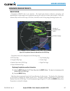
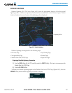
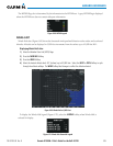
TheMETARagcolorisdeterminedbytheinformationintheMETARtext.AgrayMETARagisdisplayed
whentheMETARtextdoesnotcontainadequateinformation.
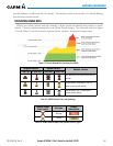
Figure 6-68 METAR Legend
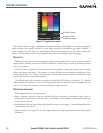
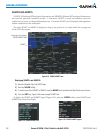
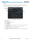
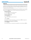
WINDS ALOFT
WindsAloftdata(Figure6-69)showstheforecastedwindspeedanddirectionatthesurfaceandatselected
altitudes.Altitudecanbedisplayedin3,000-footincrementsfromthesurfaceupto42,000feetMSL.
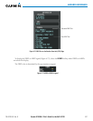
Displaying Winds Aloft data:
1) Select the Weather Data Link (GFDS) Page.
2) Press the
MORE WX
Softkey.
3) Press the
WIND
Softkey.
4) Select the desired altitude level: SFC (surface) up to 42,000 feet. Select the
NEXT
or
PREV
Softkey to cycle
through the altitude softkeys. The
WIND
Softkey label changes to reflect the altitude selected.
Figure 6-69 Winds Aloft at 3,000 Feet
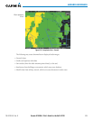
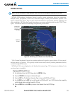
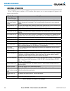
TodisplaytheWindsAloftlegend(Figure6-70),selectthe
LEGEND
SoftkeywhenWindsAloftis
selected for display.
Figure 6-70 Winds Aloft Data with Legend