


190-01255-00 Rev. B
Garmin G1000H
™
Pilot’s Guide for the Bell 407GX
20
SYSTEM OVERVIEW
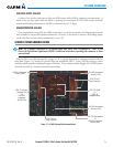
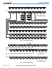
MFD SOFTKEYS
Level 1 Level 2 Level 3 Description
ENGINE
Displays the EIS-Engine Page
CAS ↑
Scroll up (Displayed only when a sufficient
number of items are displayed in the
Crew Alerting System Display to warrant
scrolling)
CAS ↓
Scroll down (Displayed only when a
sufficient number of items are displayed
in the Crew Alerting System Display to
warrant scrolling)
PWR CHK
Displays fuel system softkeys
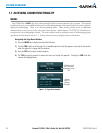
MAP
Enables second-level Navigation Map
softkeys
TRAFFIC
Displays traffic information on Navigation
Map
TOPO
Displays topographical data (e.g.,
coastlines, terrain, rivers, lakes) and
elevation scale on Navigation Map
AIRWAYS
Displays airways on the map; cycles
through the following:
AIRWAYS: No airways are displayed
AIRWY ON: All airways are displayed
AIRWY LO: Only low altitude airways
are displayed
AIRWY HI: Only high altitude airways
are displayed
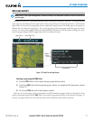
NEXRAD
Displays NEXRAD weather and coverage
information on Navigation Map (optional
feature)
XM LTNG
Displays XM lightning information on
Navigation Map (optional feature)
METAR
Displays METAR flags on airport symbols
shown on the Navigation Map
LEGEND
Displays the legend for the selected
weather products. Available only when
NEXRAD, XM LTNG, and/or METAR
softkeys are selected.
BACK
Returns to top-level softkeys