


190-01255-00 Rev. B
Garmin G1000H
™
Pilot’s Guide for the Bell 407GX
526
APPENDIX F
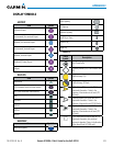
MISCELLANEOUS
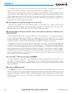
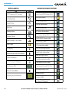
Item Symbol
ARTCC Frequency or FSS Frequency
Default Map Pointer
Elevation Pointer
Wind Vector
Measuring Pointer
Overzoom Indicator
Terrain Proximity or TAWS Enabled
Traffic Enabled
User Waypoint
Vertical Navigation Along Track Waypoint
Parallel Track Waypoint
Unanchored Flight Path Waypoint
Top of Descent (TOD)
Bottom of Descent (BOD)
Navigating using Dead Reckoning
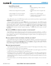
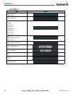
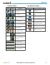
HAZARD AVOIDANCE FEATURES
Feature Symbol
Terrain Proximity/TAWS display enabled
Traffic display enabled
NEXRAD display enabled
Cloud Top display enabled
Echo Top display enabled
XM Lightning display enabled
Cell Movement display enabled
SIGMETs/AIRMETs display enabled
METARs display enabled
City Forecast display enabled
Surface Analysis display enabled
Freezing Levels display enabled
Winds Aloft display enabled
County Warnings display enabled
Cyclone Warnings display enabled
Icing Potential (CIP and SLD) (ICNG)
Pilot Weather Report (PIREPs)
Air Report (AIREPs)
Turbulence (TURB)
Loss of hazard avoidance feature
(due to loss of GPS position)