


190-01255-00 Rev. B
Garmin G1000H
™
Pilot’s Guide for the Bell 407GX
341
HAZARD AVOIDANCE
fromthealtimeter)todifferfromtheGSLaltitude.Thisvariationresultsintheaircraft’sGSLaltitudediffering
fromthebaro-correctedaltitude.
DISPLAYING HTAWS DATA
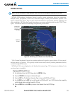
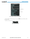
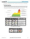
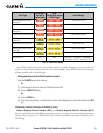
HTAWS uses yellow (caution) and red (warning) to depict terrain and obstacle alerts relative to aircraft
altitude.Colorsareadjustedautomaticallyastheaircraftaltitudechanges.ThecolorsandsymbolsinFigure
6-74andTables6-7and6-8areusedtorepresentterrain,obstacles,andpotentialimpactpoints.
Figure 6-74 Terrain Altitude/Color Correlation for HTAWS
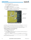
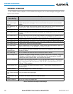
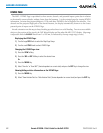
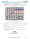
Unlighted Obstacle Lighted Obstacle
Obstacle Location
< 1000’ AGL > 1000’ AGL < 1000’ AGL > 1000’ AGL
Red obstacle is at or above current aircraft
altitude
Yellow obstacle is between 0’ and 250’
below current aircraft altitude
Gray obstacle is 250’ or more below
current aircraft altitude
Table 6-7 HTAWS Obstacle Colors and Symbology
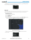
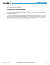
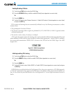
Potential Impact
Point Symbol
Alert Type
Example
Annunciation
Warning
Caution
Table 6-8 HTAWS Potential Impact Point Symbols with Alert Types