


Garmin G1000H
™
Pilot’s Guide for the Bell 407GX
190-01255-00 Rev. B376
ADDITIONAL FEATURES
8.1 SYNTHETIC VISION SYSTEM (SVS)
WARNING:
Use appropriate primary systems for navigation, and for terrain, obstacle, and traffic avoidance.
SVS is intended as an aid to situational awareness only and may not provide either the accuracy or reliability
upon which to solely base decisions and/or plan maneuvers to avoid terrain, obstacles, or traffic.
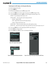
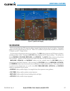
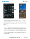
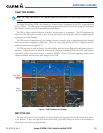
The SyntheticVisionSystem(SVS)isavisualenhancementtotheG1000HIntegratedFlightDeck.SVSdepicts
aforward-lookingattitudedisplayofthetopographyimmediatelyinfrontoftheaircraft.Theeldofviewis30
degreestotheleftand35degreestotheright.SVSinformationisshownonthePrimaryFlightDisplay(PFD),or
ontheMultifunctionDisplay(MFD)inReversionaryMode(Figure8-120).Thedepictedimageryisderivedfrom
theaircraftattitude,heading,GPSthree-dimensionalposition,andasixarc-seconddatabaseofterrain,obstacles,
andotherrelevantfeatures.Theterraindataresolutionofsixarc-seconds,meaningthatthe terrainelevation
contoursarestoredinsquaresmeasuringsixarc-secondsoneachside,isrequiredfortheoperationofSVS.Loss
ofanyoftherequireddata,includingtemporarylossoftheGPSsignal,willcauseSVStobedisableduntilthe
requireddataisrestored.
TheSVSterraindisplayshowslandcontours,largewaterfeatures,towers,andotherobstaclesover200’AGL
thatareincludedintheobstacledatabase.Culturalfeaturesonthegroundsuchasroads,highways,railroad
tracks,cities,and stateboundariesarenot displayedevenifthose featuresarefound ontheMFDmap. The
terraindisplayalsoincludesanorth–southeast–westgridwithlinesorientedwithtruenorthandspacedatone
arc-minuteintervalstoassistinorientationrelativetotheterrain.Thecolorsusedtodisplaytheterrainelevation
contoursaresimilartothatofthetopomapdisplay.
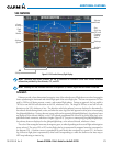
TheHelicopterTerrainAwarenessandWarningSystem(HTAWS)isintegratedwithinSVStoprovidevisualand
auditoryalertstoindicatethepresenceofterrainandobstaclethreatsrelevanttotheprojectedightpath.Terrain
alertsaredisplayedinredandyellowshadingonthePFD.
Theterraindisplayisintendedforsituationalawarenessonly.Itmaynotprovidetheaccuracyordelityon
whichtobasedecisionsandplanmaneuverstoavoidterrainorobstacles.Navigationmustnotbepredicated
solelyupontheuseoftheHTAWSterrainorobstacledatadisplayedbytheSVS.
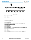
ThefollowingSVSenhancementsappearonthePFD:
•Pathways
•FlightPathMarker
•HorizonHeadingMarks
•TrafcDisplay
•AirportSigns
•RunwayDisplay
•TerrainAlerting
•ObstacleAlerting