


Garmin G1000H
™
Pilot’s Guide for the Bell 407GX
190-01255-00 Rev. B174
FLIGHT MANAGEMENT
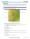
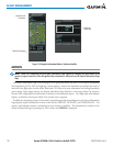
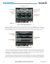
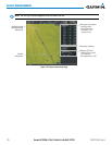
Figure 5-35 Nearest Airports Window on PFD
COM Freq. Info.
- Identification
- Frequency
Airport Identifier/
Type
Length of Longest
Runway
Approach Available
Additional Airports
(within 200 nm)
NRST Softkey
Bearing/Distance to Airport
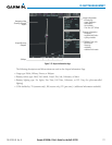
Pressing the ENT Key displays the PFD Airport Information Window for the highlighted airport. Pressing the
ENT Key again returns to the Nearest Airports Window with the cursor on the next airport in the list. Continued
presses of the ENTKeysequencesthroughtheinformationpagesforallairportsintheNearestAirportslist.
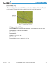
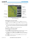
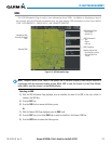
Figure 5-36 Airport Information Window on PFD
Airport Information
- Usage/Time/Elev
- Region
Airport Information
- Lat/Long
Airport Information
- ID/Type/City
- Facility
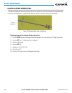
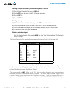
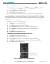
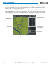
The Nearest Airports Page on the MFD is first in the group of NRST pages because of its potential use in
the event of an in-flight emergency. In addition to displaying a map of the currently selected airport and
surrounding area, the page displays nearestairportinformationinveboxeslabeled‘NEARESTAIRPORTS’,
‘INFORMATION’,‘RUNWAYS’,‘FREQUENCIES’,and‘APPROACHES’.
The selected airport is indicated by a white arrow, and a dashed white line is drawn on the navigation map
fromtheaircraftpositiontothenearestairport.Uptovenearestairports,onerunway,uptovefrequencies,
and up to five approaches are visible at one time. If there are more than can be shown, each list can be scrolled.