


190-01255-00 Rev. B
Garmin G1000H
™
Pilot’s Guide for the Bell 407GX
506
APPENDIX B
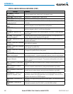
Since these databases are not stored internally in the displays, a Supplemental Data Card containing identical
database versions must be kept in each display unit.
The basemap database contains data for the topography and land features, such as rivers, lakes, and towns.
It is updated only periodically, with no set schedule. There is no expiration date.
The terrain database contains the terrain mapping data. These databases are updated periodically and have
no expiration date.
The obstacle database contains data for obstacles, such as towers, that pose a potential hazard to aircraft.
Obstacles200feetandhigherareincludedintheobstacledatabase.Itisveryimportanttonotethatnotall
obstacles are necessarily charted and therefore may not be contained in the obstacle database. This database is
updated on a 56-day cycle.
NOTE: The data contained in the terrain and obstacle databases comes from government agencies. Garmin
accurately processes and cross-validates the data, but cannot guarantee the accuracy and completeness of
the data.
The AOPAAirportDirectoryprovidesdataonairportsandheliportsthroughouttheU.S.,andoffersdetailed
informationforover5,300U.S.airports,alongwiththenamesandphonenumbersofthousandsofFBOs.This
database is updated four times per year.
The SafeTaxi database contains detailed airport diagrams for selected airports. These diagrams aid in following
ground control instructions by accurately displaying the aircraft position on the map in relation to taxiways,
ramps, runways, terminals, and services. This database is updated on a 56-day cycle.
The FliteCharts database contains procedure charts for the United States only. This database is updated on a
28-day cycle. If not updated within 180 days of the expiration date, FliteCharts will no longer function.
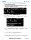
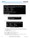
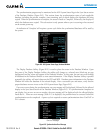
AUTOMATIC DATABASE SYNCHRONIZATION FEATURE
The automatic database synchronization feature automatically transfers the database from a single SD
database card to the SD cards on the PFD and the MFD to ensure that all databases are synchronized throughout
the system. After power-up, the system compares all copies of each applicable database. If similar databases
do not match, the most recent valid database is automatically copied to each card in the system that does not
already contain that database.
The following databases are checked and synchronized: Basemap, Safetaxi, Airport Terrain, Obstacle,
AirportDirectory(AOPA),andTerrain.ThisfeatureappliesonlytodatabasesthatarestoredontheSDcard
that resides in the bottom slot of each display. This feature does not apply to the navigation database which
is stored internally in each display, or to the charts databases (FliteCharts and ChartView) which are only
required to be present on the MFD. The typical procedure would be to download new databases to the MFD
card, then synchronize the data to the PFD.
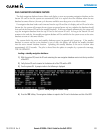
NOTE:
The 9-arc second terrain database may take as long as 100 minutes to synchronize using this method.
Therefore the user may want to transfer the data using a PC, or connect the system to a ground power
source while performing the database synchronization.