


Garmin G1000H
™
Pilot’s Guide for the Bell 407GX
190-01255-00 Rev. B340
HAZARD AVOIDANCE
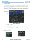
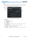
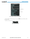
6.3 HTAWS
WARNING: Do not use HTAWS information for primary terrain avoidance. HTAWS is intended only to
enhance situational awareness.
NOTE: The data contained in the HTAWS databases comes from government agencies. Garmin accurately
processes and cross-validates the data but cannot guarantee the accuracy and completeness of the data.
NOTE: Terrain data is not displayed when the aircraft is outside of the installed terrain database coverage
region.
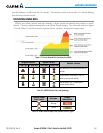
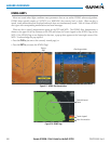
HTAWS (Helicopter Terrain Awareness and Warning System) is designed to increase situational awareness
andaidinreducingcontrolledightintoterrain(CFIT).HTAWSprovidesvisualandauralannunciationswhen
terrainandobstaclesarewithinthegivenaltitudethresholdfromtheaircraft.Thevisualandauralalertsand
warnings are advisory in nature only.
HTAWSsatisesTSO-C194requirementsforcertication.
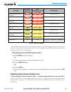
HTAWSrequiresthefollowingtooperateproperly:
•Avalidterrainandobstacledatabase
•Avalid3-DGPSpositionsolution
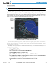
HTAWSusesterrainandobstacleinformationsuppliedbygovernmentsources.Terraininformationisbased
onterrainelevationinformationinadatabasethatmaycontaininaccuracies.Individualobstructionsmaybe
shownifavailableinthedatabase.ThedataundergoesvericationbyGarmintoconrmaccuracyofthecontent.
However,thedisplayedinformationshouldneverbeunderstoodasbeingall-inclusiveanddatamaybeinaccurate.
HTAWSusesinformationprovidedfromtheGPSreceivertoprovideahorizontalpositionandaltitude,along
withadditionalaltitudeinputfromanoptionalradaraltimeter.GPSaltitudeisderivedfromsatellitemeasurements.
GPSaltitudeisthenconvertedtotheheightabovegeodeticsealevel(GSL),whichistheheightabovemeansea
level(MSL)calculatedgeometrically.GSLaltitudeisusedtodetermineHTAWSalerts.GSLaltitudeaccuracy
isaffectedbysatellitegeometry,butisnotsubjecttovariationsinpressureandtemperaturethatnormallyaffect
pressurealtitudesensors.GSLaltitudedoesnotrequirelocalaltimetersettingstodetermineMSLaltitude.Itis
awidely-usedMSLaltitudesource.Therefore,GSLaltitudeprovidesahighlyaccurateandreliableMSLaltitude
sourcetocalculateterrainandobstaclealerts.
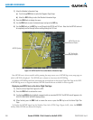
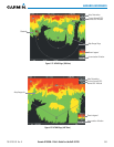
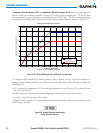
TheterrainandobstacledatabasesusedbyHTAWSarereferencedtoMSL.UsingtheGPSpositionandGSL
altitude, HTAWSdisplays a2-D picture ofthe surrounding terrainand obstaclesrelative tothe positionand
altitudeoftheaircraft.Furthermore,theGPSpositionandGSLaltitudeareusedtocalculateand“predict”the
aircraft’sightpathinrelationtothesurroundingterrainandobstacles.Inthismanner,HTAWScanprovide
advanced alerts of predicted dangerous terrain conditions.
HTAWSincorporatesaltitudeinputfromanoptionalradaraltimeterforcertainalerts.
Baro-correctedaltitude(orindicatedaltitude)isderivedbyadjustingthealtimetersettingforlocalatmospheric
conditions. Themost accurate baro-corrected altitude canbe achieved by frequently updating thealtimeter
settingtothenearestreportingstationalongtheightpath.However,becauseactualatmosphericconditions
seldommatchthestandardconditionsdenedbytheInternationalStandardAtmosphere(ISA)model(where
pressure,temperature,andlapserateshavexedvalues),itiscommonforthebaro-correctedaltitude(asread