


190-01255-00 Rev. B
Garmin G1000H
™
Pilot’s Guide for the Bell 407GX
311
HAZARD AVOIDANCE
ICING (CIP & SLD)
NOTE: Icing data cannot be displayed at the same time as NEXRAD data.
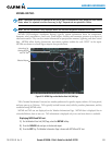
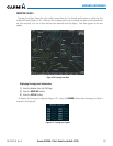
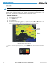
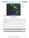
CurrentIcingProduct(CIP)datashowsagraphicalviewofthecurrenticingenvironment(Figure6-38).
Icingseverityisdisplayedinfourcategories:light,moderate,severe,andextreme(notspecictoaircrafttype).
TheCIPproductisnotaforecast,butapresentationofthecurrentconditionsatthetimeoftheanalysis.
SupercooledLarge Droplet (SLD)icing conditions are characterizedby the presence of relatively large,
supercooledwaterdropletsindicativeoffreezingdrizzleandfreezingrainaloft.SLDthreatareasaredepicted
asmagentadotsovertheCIPcolors.
Displaying Icing data:
1) Select the Weather Data Link (XM) Page.
2) Press the
MORE WX
Softkey.
3) Press the
ICNG
Softkey.
4) Select the desired altitude level: 1,000 feet up to 30,000 feet. Press the
NEXT
or
PREV
Softkey to cycle through
the altitude softkeys. The
ICNG
Softkey label changes to reflect the altitude selected.
SLD
Threat
Figure 6-38 Icing Data at 6,000 Feet
Icing
Potential
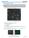
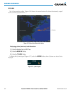
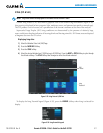
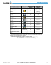
TodisplaytheIcingPotentiallegend(Figure6-39),pressthe
LEGEND
SoftkeywhenIcingisselectedfor
display.
Figure 6-39 Icing Potential Legend