


Garmin G1000H
™
Pilot’s Guide for the Bell 407GX
190-01255-00 Rev. B384
ADDITIONAL FEATURES
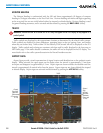
HORIZON HEADING
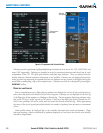
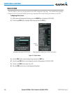
The Horizon Heading is synchronized with the HSI and shows approximately 60 degrees of compass
headingin30-degreeincrementsontheZeroPitchLine.Horizonheadingtickmarksanddigitsappearing
onthezeropitchlinearenotvisiblebehindeithertheairspeedoraltitudedisplay.HorizonHeadingisused
forgeneralheadingawareness,andisactivatedanddeactivatedbypressingtheHRZN HDGSoftkey.
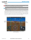
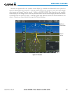
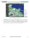
TRAFFIC
WARNING:
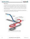
Intruder aircraft at or below 500 ft. AGL may not appear on the SVS display or may appear as a
partial symbol.
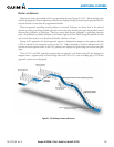
Trafcsymbolsaredisplayedintheirapproximatelocationsasdeterminedbytherelatedtrafcsystems.
Trafcsymbolsaredisplayed inthreedimensions,appearinglargerastheyaregettingcloser,andsmaller
whentheyarefurtheraway.Trafcwithin250feetlaterallyoftheaircraftwillnotbedisplayedontheSVS
display.TrafcsymbolsandcoloringareconsistentwiththatusedfortrafcdisplayedintheInsetmapor
MFDtrafcpage.Ifthetrafcaltitudeisunknown,thetrafcwillnotbedisplayedontheSVSdisplay.For
moredetailsrefertothetrafcsystemdiscussionintheHazardAvoidancesection.
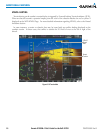
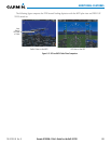
AIRPORT SIGNS
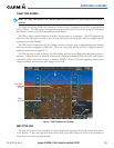
AirportSignsprovideavisualrepresentationofairportlocationandidenticationonthesyntheticterrain
display. Whenactivated,thesigns appearonthedisplaywhen theaircraftisapproximately15nm from
anairportanddisappearatapproximately4.5nm.Airportsignsareshownwithouttheidentieruntilthe
aircraftisapproximately8nauticalmilesfromtheairport.Airportsignsarenotshownbehindtheairspeed
oraltitudedisplay.AirportsignsareactivatedanddeactivatedbypressingtheAPTSIGNSSoftkey.
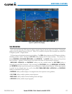
Figure 8-8 Airport Signs
Airport
Sign with
Identifier
(Between
4.5 nm and
8 nm)
Airport
Sign
without
Identifier
(Between
8 nm and
15 nm)
Traffic