


190-01255-00 Rev. B
Garmin G1000H
™
Pilot’s Guide for the Bell 407GX
283
FLIGHT MANAGEMENT
5.12 ABNORMAL OPERATION
ThissectiondiscussestheDeadReckoningmodeofoperationandthesubsequentindications.
NOTE: Dead Reckoning Mode only functions in Enroute (ENR) or Oceanic (OCN) phase of flight. In all other
phases, an invalid GPS solution produces a “NO GPS POSITION” annunciation on the map and the system
stops using GPS.
While in Enroute or Oceanic phase of flight, if the system detects an invalid GPS solution or is unable to
calculate a GPS position, the system automatically reverts to Dead Reckoning (DR) Mode. In DR Mode, the system
uses its last-known position combined with continuously updated airspeed and heading data (when available) to
calculate and display the aircraft’s current estimated position.
It is important to note that estimated navigation data supplied by the system in DR Mode may become increasingly
unreliable and must not be used as a sole means of navigation. If while in DR Mode airspeed and/or heading data
is also lost or not available, the DR function may not be capable of accurately tracking estimated position and,
consequently,thesystemmaydisplayapaththatisdifferentthantheactualmovementoftheaircraft.Estimated
position information displayed by the system through DR while there is no heading and/or airspeed data available
should not be used for navigation.
DR Mode is inherently less accurate than the standard GPS/WAAS Mode due to the lack of satellite measurements
needed to determine a position. Changes in wind speed and/or wind direction compounds the relative inaccuracy
ofDRMode.Becauseofthisdegradedaccuracy,othernavigationequipmentmustberelieduponforposition
awareness until GPS-derived position data is restored.
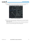
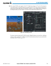
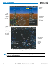
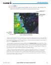
DRModeisindicatedonthe systembytheappearance oftheletters‘DR’ superimposedinyellowover the
‘ownaircraft’symbolasshowninFigure5-146.Inaddition,‘DR’isprominentlydisplayedinyellowontheHSI
slightly above and to the right of the aircraft symbol on the CDI as shown in Figure 5-146. The CDI deviation bar
isremovedfromthedisplay.Lastly,butatthesametime,a‘GPSNAVLOST’alertmessageappearsonthePFD.
Normal navigation using GPS/WAAS source data resumes automatically once a valid GPS solution is restored.
As a result of operating in DR Mode, all GPS-derived data is computed based upon an estimated position and
is displayed as yellow text on the display to denote degraded navigation source information as shown in Figure
5-146.
Also, while the system is in DR Mode, some terrain functions are disabled. Additionally, the accuracy of all
nearest information (airports, airspaces, and waypoints) is questionable. Finally, airspace alerts continue to
function, but with degraded accuracy.