


190-00728-04 Rev. A
Embraer Prodigy
®
Flight Deck 100 Pilot’s Guide
16
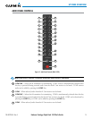
SYSTEM OVERVIEW
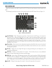
Level 1 Level 2 Level 3 Level 4
Description
DCLTR (3)
Selects desired amount of map detail; cycles through
declutter levels:
DCLTR (No Declutter): All map features visible
DCLTR-1: Declutters land data
DCLTR-2: Declutters land and SUA data
DCLTR-3: Removes everything except for the
active flight plan
WX LGND
Displays icon and age on the Inset Map for the selected
weather products (optional)
TRAFFIC
Cycles through traffic display options:
TRFC-1: Traffic displayed on inset map
TRFC-2: Traffic Map Page is displayed in the inset
map window
TOPO
Displays topographical data (e.g., coastlines, terrain,
rivers, lakes) and elevation scale on Inset Map
TERRAIN
Displays terrain information on Inset Map (not avail-
able with TAWS-A)
NEXRAD
Displays NEXRAD weather and coverage information
on Inset Map (optional feature)
XM LTNG
Displays SiriusXM Weather lightning information on
Inset Map (optional feature)
METAR
Displays METAR flags on airport symbols shown on the
Inset Map
SENSOR
Displays softkeys for selecting the #1 and #2 AHRS and
Air Data Computers
ADC1
Selects the #1 Air Data Computer
ADC2
Selects the #2 Air Data Computer
ADCSTBY
Selects the standby air data input
AHRS1
Selects the #1 AHRS
AHRS2
Selects the #2 AHRS
ATTSTBY
Selects the standby attitude input. Heading input will
come from the #1 AHRS.
PFD
Displays second-level softkeys for additional PFD con-
figurations
SYN VIS
Displays the softkeys for enabling or disabling
Synthetic Vision features
PATHWAY
Displays rectangular boxes representing the horizontal
and vertical flight path of the active flight plan
SYN TERR
Enables synthetic terrain depiction
HRZN HDG
Displays compass heading along the Zero-Pitch line