


Embraer Prodigy
®
Flight Deck 100 Pilot’s Guide
190-00728-04 Rev. A268
FLIGHT MANAGEMENT
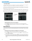
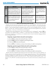
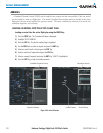
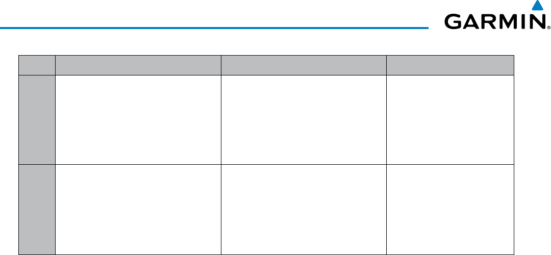
White Text Light Blue Text Light Blue Subdued Text
Large
Text
Altitude calculated by the system
estimating the altitude of the aircraft as
it passes over the navigation point. This
altitude is provided as a reference and is
not designated to be used in determining
vertical speed and deviation guidance.
Altitude has been entered manually.
Altitude is designated for use in giving
vertical speed and deviation guidance.
Altitude does not match the published
altitude in navigation database or no
published altitude exists.
The system cannot use this
altitude in determining vertical
speed and deviation guidance
because of an invalid constraint
condition.
Small
Text
Altitude is not designated to be used in
determining vertical speed and deviation
guidance. Altitude has been retrieved
from the navigation database and is
provided as a reference.
Altitude is designated for use in giving
vertical speed and deviation guidance.
Altitude has been retrieved from the
navigation database or has been entered
manually and matches a published
altitude in the navigation database.
The system cannot use this
altitude in determining vertical
speed and deviation guidance
because of an invalid constraint
condition.
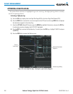
Table 5-8 Altitude Constraint Size and Color Coding
Altitudes associated with arrival and approach procedures are “auto-designated”. This means the system
automatically uses the altitudes loaded with the arrival or approach for giving vertical speed and deviation
guidance. Note that these altitudes are displayed as blue text up to, but not including, the FAF. The FAF is
always a “reference only” altitude and cannot be designated, unless the selected approach does not provide
vertical guidance. In this case, the FAF altitude can be designated.
Altitudes that have been designated for use in vertical guidance can be “un-designated” using the CLR Key.
The altitude is now displayed only as a reference. It is not used to give vertical guidance. Other displayed
altitudes may change due to re-calculations or be rendered invalid as a result of manually changing an altitude
to a non-designated altitude.
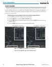
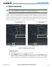
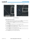
Designating a waypoint altitude to be used for vertical guidance:
1) Press the FPL Key to display the Active Flight Plan Page on the MFD.
2) Press the FMS Knob, and turn to highlight the desired waypoint altitude.
3) Turn the small FMS Knob to enter editing mode.
4) Press the ENT Key. The altitude is now shown in blue, indicating it is usable for vertical guidance.
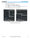
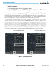
Designating a procedure waypoint altitude to be used for vertical guidance:
1) Press the FPL Key to display the Active Flight Plan Page on the MFD.
2) Press the FMS Knob, and turn to highlight the desired waypoint altitude.
3) Press the ENT Key. The altitude is now shown in blue, indicating it is usable for vertical guidance.
Altitude constraints are displayed and entered in feet mean sea level (MSL) values to the nearest hundred. An
altitude constraint in feet above ground level (AGL) format is supported for airports. When a database altitude
restriction is displayed, the system allows entry of a different altitude when creating a waypoint, effectively
overriding the database restriction (only before the FAF). When a database altitude restriction of type “AT or
ABOVE” or “AT or BELOW” is activated, the system uses the “AT” portion of the restriction to define the vertical
profile.