


Embraer Prodigy
®
Flight Deck 100 Pilot’s Guide
190-00728-04 Rev. A
392
HAZARD AVOIDANCE
6.4 TAWS-A
WARNING: Do not use TAWS information for primary terrain avoidance. TAWS-A is intended only to enhance
situational awareness.
NOTE: Terrain data is not displayed when the aircraft is outside of the installed terrain database coverage
area.
NOTE: The data contained in the TAWS databases comes from government agencies. Garmin accurately
processes and cross-validates the data but cannot guarantee the accuracy and completeness of the data.
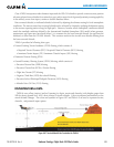
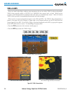
TAWS-A (Terrain Awareness and Warning System - Class A) is an optional feature designed to increase
situationalawarenessandaidinreducingcontrolledightintoterrain(CFIT).TAWS-Aprovidesvisualandaural
annunciationswhenterrainandobstaclesarewithinthegivenaltitudethresholdfromtheaircraft.Thedisplayed
alertsandwarningsareadvisoryinnatureonly.WhenTAWS-Aisinstalled,itsupersedestheTAWS-Bfeature.
TAWS-AsatisesTSO-C151bClassAandTSO-92crequirementsforcertication.
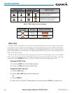
ClassATAWSrequiresthefollowingcomponents:
•Avalidterrain/obstacle/airportterraindatabase
•Avalid3-DGPSpositionsolution
•Validapandlandinggearstatusinputs
•Avalidradaraltimeter
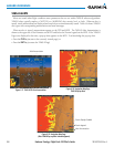
TAWS-Ausesterrainandobstacleinformationsuppliedbygovernmentsources.Terraininformationisbased
onterrainelevationinformationinadatabasethatmaycontaininaccuracies.Individualobstructionsmaybe
shownifavailableinthedatabase.ThedataundergoesvericationbyGarmintoconrmaccuracyofthecontent,
perTSO-C151b.However,thedisplayedinformationshouldneverbeunderstoodasbeingall-inclusiveanddata
may be inaccurate.
TAWS-A uses information from the GPSreceiver to provide a horizontalposition and altitude, alongwith
additionalaltitudeinput fromtheradar altimeter. GPSaltitudeisderived fromsatellitemeasurements. GPS
altitude is then converted to the height above geodeticsealevel(GSL),whichistheheightabovemeansealevel
(MSL)calculatedgeometrically.GSLaltitudeisusedinparttodetermineTAWS-Aalerts.GSLaltitudeaccuracy
is affected by satellite geometry, but is not subject to variations in pressure and temperature that normally affect
pressurealtitudesensors.GSLaltitudedoesnotrequirelocalaltimetersettingstodetermineMSLaltitude.Itis
awidely-usedMSLaltitudesource.Therefore,GSLaltitudeprovidesahighlyaccurateandreliableMSLaltitude
source to calculate terrain and obstacle alerts.
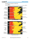
TheterrainandobstacledatabasesusedbyTAWS-Aarereferencedtomeansealevel(MSL).UsingtheGPS
positionandGPS-GSLaltitude,TAWS-Adisplaysa2-Dpictureofthesurroundingterrainandobstaclesrelative
tothepositionandaltitudeoftheaircraft.Furthermore,the GPSpositionandGPS-GSLaltitudeareusedto
calculate and “predict” the aircraft’s ight path in relation to the surrounding terrain and obstacles. In this
manner,TAWS-Acanprovideadvancedalertsofpredicteddangerousterrainconditions.