


Embraer Prodigy
®
Flight Deck 100 Pilot’s Guide
190-00728-04 Rev. A
378
HAZARD AVOIDANCE
6.3 TAWS-B
WARNING: Do not use TAWS information for primary terrain avoidance. TAWS is intended only to enhance
situational awareness.
NOTE: Terrain data is not displayed if the aircraft is outside of the installed terrain database coverage area.
NOTE: The data contained in the TAWS databases comes from government agencies. Garmin accurately
processes and cross-validates the data but cannot guarantee the accuracy and completeness of the data.
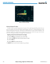
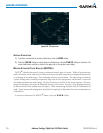
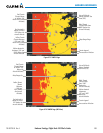
TAWS-B(TerrainAwarenessandWarningSystem-ClassB)providesincreasedsituationalawarenessandaids
inreducingcontrolledightintoterrain(CFIT).TAWS-Bprovidesvisualandauralannunciationswhenterrain
andobstaclesarewithinthegivenaltitudethresholdfromtheaircraft.Thedisplayedalertsandwarningsare
advisory in nature only.
TAWS-BsatisesTSO-C151bClassBrequirementsforcertication.
TAWS-Brequiresthefollowingtooperateproperly:
•Avalidterrain/obstacle/airportterraindatabase
•Avalid3-DGPSpositionsolution
TAWS-Busesterrainandobstacleinformationsuppliedbygovernmentsources.Terraininformationisbased
onterrainelevationinformationinadatabasethatmaycontaininaccuracies.Individualobstructionsmaybe
shownifavailableinthedatabase.Garminveriesthedatatoconrmaccuracyofthecontent,perTSO-C151b.
However,thedisplayedinformationshouldneverbeunderstoodasbeingall-inclusiveanddatamaybeinaccurate.
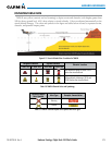
TAWS-BusesinformationprovidedfromtheGPSreceivertoprovideahorizontalpositionandaltitude.GPS
altitudeisderivedfromsatellitemeasurements.GPSaltitudeisthenconvertedtotheheightabovegeodetic sea
level(GSL),whichistheheightabovemeansealevel(MSL)calculatedgeometrically.GSLaltitudeisusedto
determineTAWS-Balerts.GSLaltitudeaccuracyisaffectedbysatellitegeometry,butisnotsubjecttovariations
inpressureandtemperaturethatnormallyaffectpressurealtitudesensors.GSLaltitudedoesnotrequirelocal
altimetersettingstodetermineMSLaltitude.Itisawidely-usedMSLaltitudesource.Therefore,GSLaltitude
providesahighlyaccurateandreliableMSLaltitudesourcetocalculateterrainandobstaclealerts.
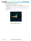
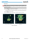
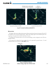
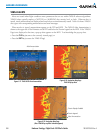
TheterrainandobstacledatabasesusedbyTAWS-BarereferencedtoMSL.UsingtheGPSpositionandGSL
altitude,TAWS-Bdisplays a2-D picture ofthe surroundingterrain andobstacles relativeto theposition and
altitudeoftheaircraft.Furthermore,theGPSpositionandGSLaltitudeareusedtocalculateand“predict”the
aircraft’sightpathinrelationtothesurroundingterrainandobstacles.Inthismanner,TAWS-Bcanprovide
advanced alerts of predicted dangerous terrain conditions.
Baro-correctedaltitude(orindicatedaltitude)isderivedbyadjustingthealtimetersettingforlocalatmospheric
conditions. Themost accurate baro-corrected altitude can beachieved by frequently updatingthe altimeter
setting to the nearest reporting station along the flight path. However, because actual atmospheric conditions
seldommatchthestandardconditionsdenedbytheInternationalStandardAtmosphere(ISA)model(where
pressure,temperature,andlapserateshavexedvalues),itiscommonforthebaro-correctedaltitude(asread
fromthealtimeter)todifferfromtheGSLaltitude.Thisvariationresultsintheaircraft’sGSLaltitudediffering
fromthebaro-correctedaltitude.